
IMAGES TAKEN NEAR TO
Colwick Road, NOTTINGHAM, NG2 4AN
Introduction
This page details the photographs taken nearby to Colwick Road, NG2 4AN by members of the Geograph project.
The Geograph project started in 2005 with the aim of publishing, organising and preserving representative images for every square kilometre of Great Britain, Ireland and the Isle of Man.

There are currently over 7.5m images from over14,400 individuals and you can help contribute to the project by visiting https://www.geograph.org.uk
Image Map
Images are licensed for reuse under creativecommons.org/licenses/by-sa/2.0
Notes
- Clicking on the map will re-center to the selected point.
- The higher the marker number, the further away the image location is from the centre of the postcode.
Image Listing (126 Images Found)
Images are licensed for reuse under creativecommons.org/licenses/by-sa/2.0
Image
Details
Distance
1
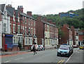
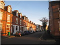
Colwick Road and Colwick Woods
A view from the corner of Trent Lane on an overcast Sunday morning.
Image: © John Sutton
Taken: 23 Jun 2013
0.01 miles
2
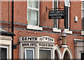
Sneinton: signwriter's art
A delightful survival, on Colwick Road. The Gothic-arched doorways and the blue-brick and terra-cotta details are typical of those of thousands of similar terraces built in the city's inner suburbs in the last quarter of the nineteenth century. For a wider view of the terrace, from the corner of Trent Lane, see Image
Image: © John Sutton
Taken: 15 Apr 2011
0.03 miles
3
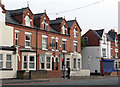
Sneinton: bus stop and barber's, Colwick Road
These three-storey terraced houses, with their Gothic doorways, substantial dormers and blue-brick and terra-cotta details, are typical of thousands built in the city's inner suburbs in the last quarter of the nineteenth century. For a close-up of the barber's shop, see Image
Image: © John Sutton
Taken: 15 Apr 2011
0.03 miles
6
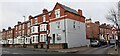
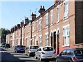
Houses on Colwick Road at Baden Powell Road junction
There is an Ordnance Survey benchmark Image on the right hand face of the house at the corner, about 5 feet from the junction of the house and its front side wall
Image: © Roger Templeman
Taken: 28 Jan 2022
0.05 miles
7
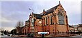
St Christopher's Church at Colwick Road / Trent Road junction
Ordnance Survey documents indicate that a benchmark was levelled in 1962 at 26.252m above Newlyn Datum on the corner of the wall, and verified in 1985
Image: © Roger Templeman
Taken: 28 Jan 2022
0.05 miles
8

St Christopher, Colwick Road - clock
The church has no tower, so instead of the more common flatbed clock with external dial, the church clock is of the bracket-mounted type more often seen outside shops and the like. A Diocesan history website says it is electrically driven, installed c.1930 and renovated in 2003. But the time shown is not correct for the time of the photo (11.04 am). https://southwellchurches.nottingham.ac.uk/sneinton-st-christopher/hclock.php
Image: © Stephen Craven
Taken: 2 Jun 2026
0.05 miles
9
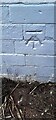
Benchmark on #155 Colwick Road (Baden Powell Road face)
Ordnance survey cut mark benchmark levelled at 25.542m above Newlyn Datum verified 1962
Image: © Roger Templeman
Taken: 28 Jan 2022
0.06 miles
10
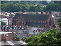
St. Christopher's Church, Sneinton
Taken from Green's Mill
Image: © Andrew Abbott
Taken: 2 Aug 2008
0.06 miles