IMAGES TAKEN NEAR TO
NG24 5AZ
Introduction
This page details the photographs taken nearby to NG24 5AZ by members of the Geograph project.
The Geograph project started in 2005 with the aim of publishing, organising and preserving representative images for every square kilometre of Great Britain, Ireland and the Isle of Man.

There are currently over 7.5m images from over14,400 individuals and you can help contribute to the project by visiting https://www.geograph.org.uk
Image Map
Images are licensed for reuse under creativecommons.org/licenses/by-sa/2.0
Notes
- Clicking on the map will re-center to the selected point.
- The higher the marker number, the further away the image location is from the centre of the postcode.
Image Listing (8 Images Found)
Images are licensed for reuse under creativecommons.org/licenses/by-sa/2.0
Image
Details
Distance
1
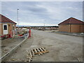
New development near Fernwood
Position of camera and subject somewhat approximate. I will correct them when OS mapping catches up.
Image: © Jonathan Thacker
Taken: 18 Sep 2022
0.04 miles
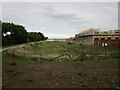
2
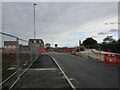
Construction of a new roundabout near Fernwood
Image: © Jonathan Thacker
Taken: 18 Sep 2022
0.06 miles
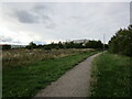
3
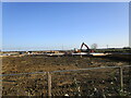
New housing under construction
The southward expansion of Fernwood.
Image: © Jonathan Thacker
Taken: 2 Dec 2021
0.07 miles
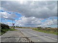
4
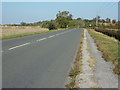
Great North Road
The old A1 south of Balderton
Image: © Richard Croft
Taken: 30 Sep 2011
0.08 miles
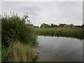
6
Run-off catchment area and new housing alongside Hollowdyke Lane, Fernwood
Image: © Jonathan Thacker
Taken: 18 Sep 2022
0.11 miles
8
The Great North Road junction with Shire Lane
Image: © Steve Fareham
Taken: 11 Sep 2012
0.17 miles