IMAGES TAKEN NEAR TO
Parliament Walk, NEWARK, NG24 4WB
Introduction
This page details the photographs taken nearby to Parliament Walk, NG24 4WB by members of the Geograph project.
The Geograph project started in 2005 with the aim of publishing, organising and preserving representative images for every square kilometre of Great Britain, Ireland and the Isle of Man.

There are currently over 7.5m images from over14,400 individuals and you can help contribute to the project by visiting https://www.geograph.org.uk
Image Map
Images are licensed for reuse under creativecommons.org/licenses/by-sa/2.0
Notes
- Clicking on the map will re-center to the selected point.
- The higher the marker number, the further away the image location is from the centre of the postcode.
Image Listing (343 Images Found)
Images are licensed for reuse under creativecommons.org/licenses/by-sa/2.0
Image
Details
Distance
1
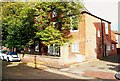
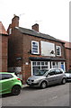
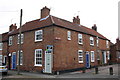
Parliament Street, Newark on Trent, Notts.
A large Georgian house with its front elevation on Parliament Street and another elevation on Parliament Court. Millgate, a much busier 'through' road can be glimpsed beyond the cars.
Image: © David Hallam-Jones
Taken: 29 Oct 2017
0.02 miles
2
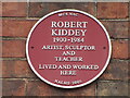
Plaque to Robert Kiddey
On right hand side frontage of former Infants School at 5A King St Image
Image: © El Loco
Taken: 18 Dec 2021
0.03 miles
3
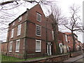
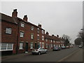
Parliament Street, Newark on Trent, Notts.
It seems likely that some of the windows in this Georgian house - off Millgate - were victims of "The Window Tax", a revenue-raising levy that was imposed upon upper and middle class house owners between 1696-1851.
Image: © David Hallam-Jones
Taken: 29 Oct 2017
0.03 miles
4
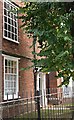
Former Holy Trinity Presbytery
Once known as the Old Hall.
The adjacent Holy Trinity Roman Catholic church was demolished in the early 1980s. The former Presbytery was clearly a house of some importance dating from the seventeenth century and at that time being on the very fringe of the town https://historicengland.org.uk/listing/the-list/list-entry/1196414
Image: © Jonathan Thacker
Taken: 28 Feb 2019
0.03 miles
5
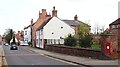
Millgate, Newark on Trent, Notts.
This post box is situated at the junction of Parliament Street with Millgate. Newark town centre can be reached in the distance, way beyond The Watermill pub that is visible on the right. Millgate is part of one of this town's heritage trails. Perhaps Parliament Street was so named as an area in which Parliamentarian troops had been based during historical battles of yesteryear?
Image: © David Hallam-Jones
Taken: 29 Oct 2017
0.03 miles
6
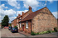
Newark, Notts (Mill Gate Area)
This single-storey building on King Street in the Mill Gate conservation area is a former school. It is now a private residence. (No other information available). Mill Gate lies beyond the striped barriers.
Image: © David Hallam-Jones
Taken: 21 Jul 2012
0.03 miles
7
#17 Parliament Street
There is an OS benchmark Image on the near corner of the house, front face
Image: © Roger Templeman
Taken: 2 May 2016
0.03 miles
8
The east side of Millgate south of Parliament Street
A mixture of eighteenth and nineteenth century houses.
Image: © Jonathan Thacker
Taken: 28 Feb 2019
0.03 miles
10
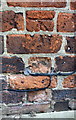
Benchmark on #17 Parliament Street
Ordnance Survey cut mark benchmark described on the Bench Mark Database at http://www.bench-marks.org.uk/bm75308
Image: © Roger Templeman
Taken: 2 May 2016
0.03 miles