IMAGES TAKEN NEAR TO
Edward Avenue, NEWARK, NG24 4UZ
Introduction
This page details the photographs taken nearby to Edward Avenue, NG24 4UZ by members of the Geograph project.
The Geograph project started in 2005 with the aim of publishing, organising and preserving representative images for every square kilometre of Great Britain, Ireland and the Isle of Man.

There are currently over 7.5m images from over14,400 individuals and you can help contribute to the project by visiting https://www.geograph.org.uk
Image Map
Images are licensed for reuse under creativecommons.org/licenses/by-sa/2.0
Notes
- Clicking on the map will re-center to the selected point.
- The higher the marker number, the further away the image location is from the centre of the postcode.
Image Listing (546 Images Found)
Images are licensed for reuse under creativecommons.org/licenses/by-sa/2.0
Image
Details
Distance
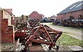
1
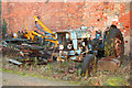
Three wheeler
A deacying tractor with a wheel missing, in a yard off Millgate
Image: © Richard Croft
Taken: 28 Nov 2012
0.05 miles
2
Any old iron
Yard off Millgate, Newark.
Image: © Jonathan Thacker
Taken: 28 Feb 2019
0.05 miles
3
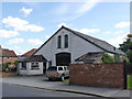
Workshop, Millgate
The double window in the gable gives a first impression that this might have been a chapel, but it has almost certainly always been a workshop of some sort. The surrounding area is full of rusting agricultural machinery.
Image: © Alan Murray-Rust
Taken: 31 Aug 2012
0.05 miles
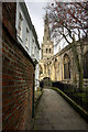
4
Pelham Street, looking towards Victoria Street
The nearest house dates from the early 19th century and is Listed Grade II. At some point since the original 1992 listing, some plain sashes and casement windows have been replaced with more authentic glazing bar sashes.
Image: © Alan Murray-Rust
Taken: 31 Aug 2012
0.06 miles
5
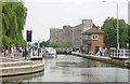
Newark Lock and Castle
Newark Lock on the River Trent and Newark Castle.
Image: © Martin Clark
Taken: Unknown
0.06 miles
6
Newark Parish Church (St Mary Magdalene)
The spire on the tower of Newark Church is about 250 feet high, and is one of the tallest parish church spires in England, surpassed only by Preston, Louth, Grantham and Kilburn.
see http://southwellchurches.nottingham.ac.uk/newark-st-mary/hfitting.php
Image: © Andy Stephenson
Taken: 16 Apr 2005
0.06 miles
7
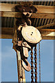
Lifting gear
Detail of the lifting gear http://www.geograph.org.uk/photo/3214116 at the British Waterways wharf on the Trent near Town Lock
Image: © Richard Croft
Taken: 5 Nov 2012
0.06 miles
8

Former Squire's Garage
Originally a Salvation Army barracks, built c1887, later a wool and flax hall, ropewalk and latterly Squire's Garage on Millgate.
Image: © Richard Croft
Taken: 28 Nov 2012
0.06 miles
9
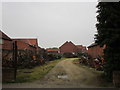
Off Millgate, Newark on Trent, Notts.
A yard adjacent to premises most recently known as "Squire's Garage". According to the local Civic Society the building functioned as a Salvation Army barracks in 1887, having been officially opened by General Booth. It has also been a wool and flax manufacturing site and a rope-creation site, i.e. a ropewalk. It also served as a garage and petrol station at a time when Millbank was designated as part of the A46. Both the garage and the yard seem in a state of disuse.
Image: © David Hallam-Jones
Taken: 29 Oct 2017
0.06 miles
10
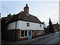
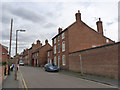
55 Millgate
Millgate which retains the line of the Roman Fosse Way through Newark was an early suburb of the town, Sadly several notable buildings were demolished during the 1950s and 60s but many still remain. 55 Millgate dates in part from the mid 17th century. https://historicengland.org.uk/listing/the-list/list-entry/1278126
Image: © Jonathan Thacker
Taken: 5 Nov 2018
0.06 miles