IMAGES TAKEN NEAR TO
Mill Gate, NEWARK, NG24 4UE
Introduction
This page details the photographs taken nearby to Mill Gate, NG24 4UE by members of the Geograph project.
The Geograph project started in 2005 with the aim of publishing, organising and preserving representative images for every square kilometre of Great Britain, Ireland and the Isle of Man.

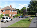
There are currently over 7.5m images from over14,400 individuals and you can help contribute to the project by visiting https://www.geograph.org.uk
Image Map
Images are licensed for reuse under creativecommons.org/licenses/by-sa/2.0
Notes
- Clicking on the map will re-center to the selected point.
- The higher the marker number, the further away the image location is from the centre of the postcode.
Image Listing (252 Images Found)
Images are licensed for reuse under creativecommons.org/licenses/by-sa/2.0
Image
Details
Distance
1
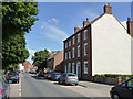
Houses on Millgate
Early 19th century terrace, originally of 3 dwellings, but now merged into two. Typical late Georgian style, Listed Grade II.
Image: © Alan Murray-Rust
Taken: 31 Aug 2012
0.02 miles
2
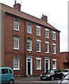
115-119 Mill Gate, Newark-on-Trent
A trio of early C19th houses with lintels and triple keystones to the windows. Grade II listed.
Image: © Stephen Richards
Taken: 22 Jun 2012
0.02 miles
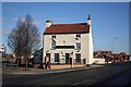
4
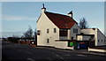
Spring House
Spring House pub in Newark
Image: © Richard Croft
Taken: 12 Mar 2011
0.03 miles
5
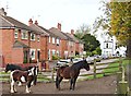
Millgate, Newark on Trent, Notts.
Horses in Millgate Field at the south-western end of Millgate (< road name). Millgate is an ancient thoroughfare that connects the town centre - ahead - with the Farndon Marina end of Newark. The River Trent passes behind these houses, running towards Newark Town Lock and Newark Castle. "The White House", i.e. 84 Millgate, in the distance was once the home of Thomas Earl (1830-1910) a one-time local maltster, mayor, M.P. and benefactor.
Image: © David Hallam-Jones
Taken: 29 Oct 2017
0.03 miles
6
Southfield House
Sheltered housing.
Image: © Jonathan Thacker
Taken: 24 Sep 2011
0.03 miles
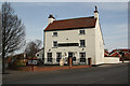
7
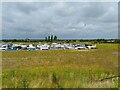
Farndon Road, Newark, Notts.
A view of The Spring House pub on Farndon Road (i.e. the B6166) looking towards Farndon, with the boundary wall of Newark Marina on the right.
Image: © David Hallam-Jones
Taken: 1 Feb 2015
0.05 miles
9
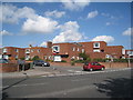
Marlow House
One of a pair of buildings, each containing 4 apartments.
The patch of green is being used to graze a pair of miniature ponies - definitely a different way of keeping the grass under control!
Image: © Alan Murray-Rust
Taken: 31 Aug 2012
0.06 miles
10
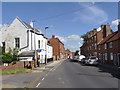
Millgate, looking north east from King Street
This was the original main road into Newark from Nottingham, developed from the 18th century onwards. Apart from anything obviously modern, all the buildings in the view are Listed Grade II.
Image: © Alan Murray-Rust
Taken: 31 Aug 2012
0.06 miles