IMAGES TAKEN NEAR TO
Mill Gate, NEWARK, NG24 4UA
Introduction
This page details the photographs taken nearby to Mill Gate, NG24 4UA by members of the Geograph project.
The Geograph project started in 2005 with the aim of publishing, organising and preserving representative images for every square kilometre of Great Britain, Ireland and the Isle of Man.

There are currently over 7.5m images from over14,400 individuals and you can help contribute to the project by visiting https://www.geograph.org.uk
Image Map
Images are licensed for reuse under creativecommons.org/licenses/by-sa/2.0
Notes
- Clicking on the map will re-center to the selected point.
- The higher the marker number, the further away the image location is from the centre of the postcode.
Image Listing (318 Images Found)
Images are licensed for reuse under creativecommons.org/licenses/by-sa/2.0
Image
Details
Distance
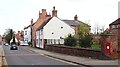
1
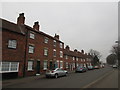
The east side of Millgate south of Parliament Street
A mixture of eighteenth and nineteenth century houses.
Image: © Jonathan Thacker
Taken: 28 Feb 2019
0.00 miles
3
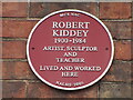
Plaque to Robert Kiddey
On right hand side frontage of former Infants School at 5A King St Image
Image: © El Loco
Taken: 18 Dec 2021
0.02 miles
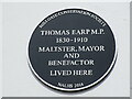
5

The White House, Millgate
This was formerly the residence of mayor Thomas Earp and shows position of plaque Image Millgate used to be the home of Newark's wealthier individuals as the prevailing winds from the SW meant that the smells of industrial Newark did not blow over the area very often.
Image: © El Loco
Taken: 23 May 2021
0.02 miles
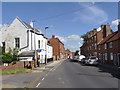
6
Millgate, Newark on Trent, Notts.
This post box is situated at the junction of Parliament Street with Millgate. Newark town centre can be reached in the distance, way beyond The Watermill pub that is visible on the right. Millgate is part of one of this town's heritage trails. Perhaps Parliament Street was so named as an area in which Parliamentarian troops had been based during historical battles of yesteryear?
Image: © David Hallam-Jones
Taken: 29 Oct 2017
0.02 miles
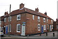
7
Millgate, looking north east from King Street
This was the original main road into Newark from Nottingham, developed from the 18th century onwards. Apart from anything obviously modern, all the buildings in the view are Listed Grade II.
Image: © Alan Murray-Rust
Taken: 31 Aug 2012
0.02 miles
8
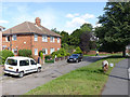
Marlow House
One of a pair of buildings, each containing 4 apartments.
The patch of green is being used to graze a pair of miniature ponies - definitely a different way of keeping the grass under control!
Image: © Alan Murray-Rust
Taken: 31 Aug 2012
0.03 miles
9
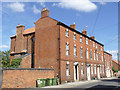
78-82 Millgate
Late 18th century Georgian houses. Note the blank 'window tax' windows of the second and third houses. Listed Grade II.
Image: © Alan Murray-Rust
Taken: 31 Aug 2012
0.03 miles
10

Millgate
Grade II listed 18th century town houses http://www.geograph.org.uk/photo/3317238 and Lenton Terrace http://www.geograph.org.uk/photo/3317230 on Millgate
Image: © Richard Croft
Taken: 5 Dec 2014
0.04 miles