IMAGES TAKEN NEAR TO
Mill Lane, NEWARK, NG24 4TT
Introduction
This page details the photographs taken nearby to Mill Lane, NG24 4TT by members of the Geograph project.
The Geograph project started in 2005 with the aim of publishing, organising and preserving representative images for every square kilometre of Great Britain, Ireland and the Isle of Man.

There are currently over 7.5m images from over14,400 individuals and you can help contribute to the project by visiting https://www.geograph.org.uk
Image Map
Images are licensed for reuse under creativecommons.org/licenses/by-sa/2.0
Notes
- Clicking on the map will re-center to the selected point.
- The higher the marker number, the further away the image location is from the centre of the postcode.
Image Listing (552 Images Found)
Images are licensed for reuse under creativecommons.org/licenses/by-sa/2.0
Image
Details
Distance
1
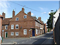
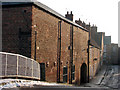
Millgate, corner of Mill Lane
The corner building and its neighbour on Millgate were originally (late 18th century) a public house (later a shop) and dwelling house, now simply residential. An odd feature here is the way that the attic floor oversails the house on Mill Lane, clearly marked by the changes in the brickwork. Listed Grade II.
Image: © Alan Murray-Rust
Taken: 31 Aug 2012
0.00 miles
2
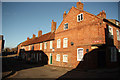
Mill Lane
Late 18th century houses on Mill Lane off Millgate
Image: © Richard Croft
Taken: 28 Nov 2012
0.01 miles
3
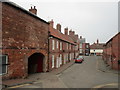
Mill Lane, Newark
Seen from Mill Lane Bridge.
Image: © Jonathan Thacker
Taken: 28 Feb 2019
0.01 miles
4
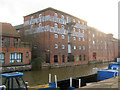
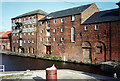
Old warehouse on the Newark Cut
A classic 1870 warehouse, complete with hoist doors. Originally a maltings built by W Duke for one of the Gilstrap family, whose monogram appears on the wall ties. Later (as the lettering shows) it became a Trent Navigation Company warehouse. Today it houses the Millgate Museum ( http://www.newark-sherwooddc.gov.uk/millgatemuseum/ ).
Image: © Trevor Rickard
Taken: 8 Jan 2012
0.02 miles
5
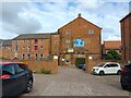
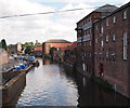
Newark: Mill Lane from the bridge
The nearest building, lit by pale winter-morning sun, is one of the former Trent Navigation warehouses, this part of which once contained a boiler house, the base of whose chimney protrudes through the roof on the river side. The cottages, with their tall chimney stacks, are from the late 18th or early 19th century, according to Pevsner.
Image: © John Sutton
Taken: 10 Dec 2010
0.02 miles
7
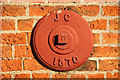
Wall Tie
Wall tie with JG 1870 on the former Trent Navigation Company warehouse on Mill Lane, now Millgate Museum.
Image: © Richard Croft
Taken: 28 Nov 2012
0.02 miles
8
![Newark historic riverside trail [9]](https://s0.geograph.org.uk/geophotos/03/81/92/3819212_2c1c4b4f_120x120.jpg)
Newark historic riverside trail [9]
The Trent Navigation Commissioners created this warehouse by extending a malting in 1880. Trail leaflet available from Newark TIC.
Image: © Christine Johnstone
Taken: 18 Jan 2014
0.02 miles
9
Newark: former Trent Navigation warehouses, 1993
This is the Trent frontage of what since 1975 has been the Millgate Museum. The continuation of this group of buildings to the right is shown in Image The warehouses along this canalised section of the river are a reminder of the once considerable barge traffic on the Trent.
Image: © John Sutton
Taken: 31 Aug 1993
0.02 miles
10
Newark, Notts (Newark Basin)
The view from Mill Bridge looking towards the Town Lock area of the basin. A row of first floor windows in the Mill Museum complex are open to provide ventilation on a rare hot summer's day. In former times this building was an oil seed meal owned by James Clark in the 1870s. The five storey beyond it was originally a malting but it was extended by the Trent Navigation Commissioners in 1880 and converted in a warehouse.
Image: © David Hallam-Jones
Taken: 21 Jul 2012
0.02 miles