IMAGES TAKEN NEAR TO
Farndon Road, NEWARK, NG24 4SW
Introduction
This page details the photographs taken nearby to Farndon Road, NG24 4SW by members of the Geograph project.
The Geograph project started in 2005 with the aim of publishing, organising and preserving representative images for every square kilometre of Great Britain, Ireland and the Isle of Man.

There are currently over 7.5m images from over14,400 individuals and you can help contribute to the project by visiting https://www.geograph.org.uk
Image Map
Images are licensed for reuse under creativecommons.org/licenses/by-sa/2.0
Notes
- Clicking on the map will re-center to the selected point.
- The higher the marker number, the further away the image location is from the centre of the postcode.
Image Listing (42 Images Found)
Images are licensed for reuse under creativecommons.org/licenses/by-sa/2.0
Image
Details
Distance
1
Site of The Traveller's Rest
Site on Farndon Road of the closed and now demolished Traveller's rest pub
Image: © Richard Croft
Taken: 24 Mar 2008
0.02 miles
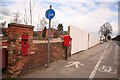
3

Victorian postbox
Former postbox now replaced with a contemporary version nearby http://www.geograph.org.uk/photo/737611
Image: © Richard Croft
Taken: 24 Mar 2008
0.02 miles
4
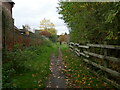
Footpath from the Trent bank to Farndon Road
Image: © Jonathan Thacker
Taken: 28 Oct 2024
0.04 miles
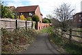
6
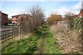
Footpath to the River Trent
Footpath from Farndon Road to the River Trent
Image: © Richard Croft
Taken: 24 Mar 2008
0.07 miles
7
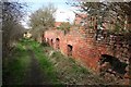
Industrial Archaeology
Now garden walls, formerly part of the maltings that stood on the site of the housing development off Farndon Road
Image: © Richard Croft
Taken: 24 Mar 2008
0.08 miles
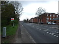
8
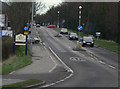
Farndon Road
The old Fosse Way entrance to Newark on Trent. Through traffic on the A46 now bypasses Newark to the west of the town.
Image: © Alan Murray-Rust
Taken: 27 Nov 2009
0.09 miles
9
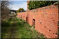
Industrial Archaeology
Now garden walls, formerly part of the maltings that stood on the site of the housing development off Farndon Road. Approaching the River Trent on the footpath.
Image: © Richard Croft
Taken: 24 Mar 2008
0.11 miles
10
Footpath to Farndon Road
From the River Trent to Farndon Road
Image: © Richard Croft
Taken: 24 Mar 2008
0.11 miles