IMAGES TAKEN NEAR TO
Farndon Road, NEWARK, NG24 4SD
Introduction
This page details the photographs taken nearby to Farndon Road, NG24 4SD by members of the Geograph project.
The Geograph project started in 2005 with the aim of publishing, organising and preserving representative images for every square kilometre of Great Britain, Ireland and the Isle of Man.

There are currently over 7.5m images from over14,400 individuals and you can help contribute to the project by visiting https://www.geograph.org.uk
Image Map
Images are licensed for reuse under creativecommons.org/licenses/by-sa/2.0
Notes
- Clicking on the map will re-center to the selected point.
- The higher the marker number, the further away the image location is from the centre of the postcode.
Image Listing (149 Images Found)
Images are licensed for reuse under creativecommons.org/licenses/by-sa/2.0
Image
Details
Distance
1
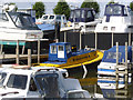
Friar Tuck tug, Newark Marina
This neatly restored diesel river tug was built by Cooks of Wivenhoe for the Docks and Inland Waterways Executive, the precursor of today's Canal and River Trust. In service until 2010, she was based at Newark-on-Trent mainly towing dredging hoppers and undertaking other maintenance work. Since restoration she has been used to tow the Newark Heritage Barge (Leicester Trader) to open days in Newark.
Image: © Alan Murray-Rust
Taken: 31 Aug 2012
0.03 miles
3
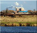
Sugar Beet Factory, Newark, Notts.
The British Sugar plc factory on the side of The Great North Road (the A616), south of Muskham, is seen here from Newark Marina. Of the 18 factories once owned by the British Sugar Corporation, only four still process beet - Bury St Edmunds (Suffolk) Cantley and Wissington (Norfolk) and Newark-on-Trent. River traffic heading for Newark would pass the marina - behind the photographer - from left to right.
Image: © David Hallam-Jones
Taken: 1 Feb 2015
0.04 miles
4
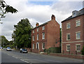
Orchard House, Farndon Road
The area to the right of the house was formerly occupied by a linen factory, established by George Scales in 1793. Apart from being at a good communications centre, there was also an excellent spring close by which enabled high quality linen to be produced. Production ceased in 1889. The buildings appear as 'disused' on maps for some time thereafter. Today the only survivor is this house built by George Scales Junior in 1806, an attractive, typical Georgian town house. Listed Grade II.
Image: © Alan Murray-Rust
Taken: 14 Sep 2012
0.05 miles
5
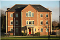
The Waterfront
Apartments at The Waterfront on Farndon Road
Image: © Richard Croft
Taken: 28 Nov 2012
0.05 miles
6
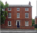
3 Farndon Road, Newark-on-Trent
Three bays and storeys, the central windows narrower than the others, which is unusual. Doorcase and elaborate fanlight (Image]). Dated 1806. Grade II listed.
Originally this served as the master's house of George and Mary Scales's Hawton Bleachworks and Linen Manufactory.
Image: © Stephen Richards
Taken: 22 Jun 2012
0.06 miles
7
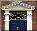
Detail of 3 Farndon Road, Newark-on-Trent
Pretty radial fanlight of this house Image The brackets are decorated with large leaves or feathers.
Image: © Stephen Richards
Taken: 22 Jun 2012
0.06 miles
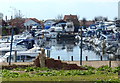
8
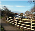
Newark Marina, Newark, Notts.
A paddock at the southern end of Mill Gate and the eastern end of Newark Marina beyond it. A car travelling towards the town centre can be seen on Farndon Road (the B6166) on the left.
Image: © David Hallam-Jones
Taken: 1 Feb 2015
0.06 miles
9
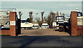
Marina Entrance, Newark, Notts.
The entrance into the marina and boatyard, off Farndon Road (the B6166). The trees mark the course of the River Trent lies. The town centre is to the right of these gates.
Image: © David Hallam-Jones
Taken: 1 Feb 2015
0.06 miles
10

Newark Marina, Newark, Notts.
A rubber-tyred gantry crane (or straddle hoist) at the side of the River Devon. Access to the River Trent is a stone's throw away, to the right.
Image: © David Hallam-Jones
Taken: 1 Feb 2015
0.06 miles