IMAGES TAKEN NEAR TO
Valley Prospect, NEWARK, NG24 4QJ
Introduction
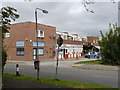
This page details the photographs taken nearby to Valley Prospect, NG24 4QJ by members of the Geograph project.
The Geograph project started in 2005 with the aim of publishing, organising and preserving representative images for every square kilometre of Great Britain, Ireland and the Isle of Man.

There are currently over 7.5m images from over14,400 individuals and you can help contribute to the project by visiting https://www.geograph.org.uk
Image Map
Images are licensed for reuse under creativecommons.org/licenses/by-sa/2.0
Notes
- Clicking on the map will re-center to the selected point.
- The higher the marker number, the further away the image location is from the centre of the postcode.
Image Listing (25 Images Found)
Images are licensed for reuse under creativecommons.org/licenses/by-sa/2.0
Image
Details
Distance
1
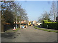
Valley Prospect
Impending roadworks.
Image: © Burgess Von Thunen
Taken: 19 Feb 2013
0.05 miles
2
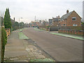
Valley Prospect
Looking south-east to the junction with Hawton Road at the end.
Image: © Trevor Rickard
Taken: 29 Jan 2012
0.08 miles
3
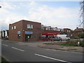
Local Shops, Hawtonville
On the corner of Riverside Road and Hawton Road.
Image: © Jonathan Thacker
Taken: 16 Apr 2011
0.08 miles
4
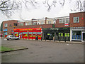
Local shops on Hawton Road
Small set of shops with a handy car park on the west side of the road. From left to right - Chinese takeaway, convenience store, off licence, newsagent, fish and chip shop, hairdresser.
Image: © Trevor Rickard
Taken: 29 Jan 2012
0.10 miles
5
Hawton Road shops
A small group of shops which have not entirely succumbed to becoming fast food outlets.
Image: © Alan Murray-Rust
Taken: 4 Sep 2012
0.10 miles
6
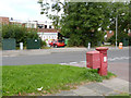
Hawton Road postbox (ref. NG24 183)
GR pillar box on the corner of Grange Road. It must have been transplanted from elsewhere, as there was no development here at all until after the Second World War.
Image: © Alan Murray-Rust
Taken: 4 Sep 2012
0.12 miles
7
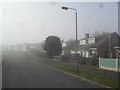
Riverside Road
A foggy day in Newark-on-Trent.
Image: © Burgess Von Thunen
Taken: 19 Feb 2013
0.15 miles
8
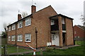
Block of flats, Grange Road
There is an OS benchmark Image on the near corner of the block above where white pipes enter a drain
Image: © Roger Templeman
Taken: 2 May 2016
0.15 miles
9
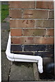
Benchmark on #234 Grange Road
Ordnance Survey cut mark benchmark described on the Bench Mark Database at http://www.bench-marks.org.uk/bm75315
Image: © Roger Templeman
Taken: 2 May 2016
0.15 miles
10
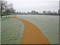
Football pitch at Devon Park
View south-west along the new footpath around the park. The ground is solid with frost, so perhaps not ideal conditions for play.
Image: © Trevor Rickard
Taken: 29 Jan 2012
0.15 miles