IMAGES TAKEN NEAR TO
Churchill Drive, NEWARK, NG24 4ND
Introduction
This page details the photographs taken nearby to Churchill Drive, NG24 4ND by members of the Geograph project.
The Geograph project started in 2005 with the aim of publishing, organising and preserving representative images for every square kilometre of Great Britain, Ireland and the Isle of Man.

There are currently over 7.5m images from over14,400 individuals and you can help contribute to the project by visiting https://www.geograph.org.uk
Image Map
Images are licensed for reuse under creativecommons.org/licenses/by-sa/2.0
Notes
- Clicking on the map will re-center to the selected point.
- The higher the marker number, the further away the image location is from the centre of the postcode.
Image Listing (29 Images Found)
Images are licensed for reuse under creativecommons.org/licenses/by-sa/2.0
Image
Details
Distance
1
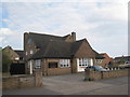
The Cardinal's Hat, Hawtonville
The local pub for this estate.
Image: © Jonathan Thacker
Taken: 16 Apr 2011
0.06 miles
2
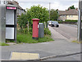
Hawton Road Post Office postbox (ref. NG24 71)
GVIR pillar box. Despite the official name, this is quite a long way from Hawton Road, and is opposite Churchill Drive Post Office.
Image: © Alan Murray-Rust
Taken: 4 Sep 2012
0.09 miles
3
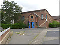
Hawtonville Community Centre
A relatively modern addition to Hawtonville on a site formerly occupied by lock-up garages.
Image: © Alan Murray-Rust
Taken: 4 Sep 2012
0.09 miles
4
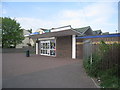
Hawtonville Post Office and Co-op store
One of the few shops remaining on this estate.
Image: © Jonathan Thacker
Taken: 16 Apr 2011
0.09 miles
5
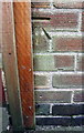
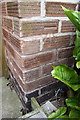
Benchmark on #55 Philip Road
Ordnance Survey cut mark benchmark described on the Bench Mark Database at http://www.bench-marks.org.uk/bm75313
Image: © Roger Templeman
Taken: 2 May 2016
0.10 miles
6
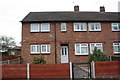
Philip Road houses
There is an OS benchmark Image on the front left hand corner of the houses, just inside the wooden gate
Image: © Roger Templeman
Taken: 2 May 2016
0.10 miles
7
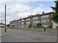
Winston Court
Maisonette blocks on Churchill Drive, part of the post-war development of Hawtonville. Both names pay tribute to one of the key figures of World War II.
Image: © Alan Murray-Rust
Taken: 4 Sep 2012
0.10 miles
8
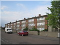
Winston Court, Churchill Drive, Hawtonville
The standard design of flats built in Newark in the 1960s. Other examples are scattered throughout the town.
Image: © Jonathan Thacker
Taken: 16 Apr 2011
0.11 miles
9
Benchmark on #21 Philip Road
Ordnance Survey cut mark benchmark described on the Bench Mark Database at http://www.bench-marks.org.uk/bm75312
Image: © Roger Templeman
Taken: 2 May 2016
0.12 miles
10
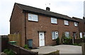
Nos. 21 and 23 Philip Road
There is an OS benchmark Image on the front of the left hand house, between its corner and the black downpipe
Image: © Roger Templeman
Taken: 2 May 2016
0.12 miles