IMAGES TAKEN NEAR TO
Monarch Place, NG24 4GH
Introduction
This page details the photographs taken nearby to Monarch Place, NG24 4GH by members of the Geograph project.
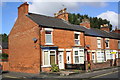
The Geograph project started in 2005 with the aim of publishing, organising and preserving representative images for every square kilometre of Great Britain, Ireland and the Isle of Man.

There are currently over 7.5m images from over14,400 individuals and you can help contribute to the project by visiting https://www.geograph.org.uk
Image Map
Images are licensed for reuse under creativecommons.org/licenses/by-sa/2.0
Notes
- Clicking on the map will re-center to the selected point.
- The higher the marker number, the further away the image location is from the centre of the postcode.
Image Listing (126 Images Found)
Images are licensed for reuse under creativecommons.org/licenses/by-sa/2.0
Image
Details
Distance
1
Cut Mark Lime Grove (garage next to 127)
Image: © Monica Stagg
Taken: 7 Sep 2015
0.05 miles
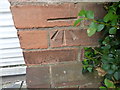
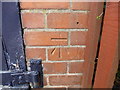
2
Benchmark on the garage of #127 Lime Grove
Ordnance Survey cut mark benchmark described on the Bench Mark Database at http://www.bench-marks.org.uk/bm70253
Image: © Roger Templeman
Taken: 2 Oct 2016
0.05 miles
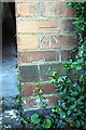
3
'Mapledene', #127 Lime Grove with external garage
There is an OS benchmark Image on the front face of the bricks on the right hand side of the garage
Image: © Roger Templeman
Taken: 2 Oct 2016
0.05 miles
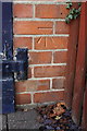
4
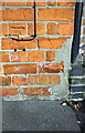
Benchmark on #54 Bowbridge Road
Ordnance Survey cut mark benchmark described on the Bench Mark Database at http://www.bench-marks.org.uk/bm79396
Image: © Roger Templeman
Taken: 2 Oct 2016
0.06 miles
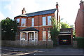
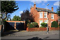
5
Houses at the Bowbridge Road / Jubilee Street junction
There is an OS benchmark Image on the side of the nearest house near its front corner
Image: © Roger Templeman
Taken: 2 Oct 2016
0.06 miles
6
Cut Mark Lime Grove (garages) Newark on Trent
Image: © Monica Stagg
Taken: 7 Sep 2015
0.07 miles
7
Benchmark on garage next to #116 Lime Grove
Ordnance Survey cut mark benchmark described on the Bench Mark Database at http://www.bench-marks.org.uk/bm70252
Image: © Roger Templeman
Taken: 2 Oct 2016
0.07 miles
8
Garages next to #116 Lime Grove
There is an OS benchmark Image on the bricks to the right of the door of the right hand garage
Image: © Roger Templeman
Taken: 2 Oct 2016
0.07 miles
9
Former Newark Hospital, London Road, Newark, Notts.
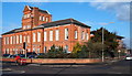
Continuing to stand proud at the junction of London Road (the B6326) and Sherwood Avenue - on which the white car is visible - is the former Newark General Hospital. Records suggest that this may have been Newark’s third hospital. The second one was a combined workhouse, hospice and gaol built in 1786 using funds from the Brown and Phillipot charity. That building became part of Hole’s Brewery (a.k.a. Castle Brewery) which still exists today, although now home to up-market apartments. This building (opened in 1881), was designed by Bliss and Saunders and built in red brick by Smith and Lunn. It cost £6,965 13s 1d. A maternity wing was added in 1939. This establishment closed in 1996 when Newark’s fourth hospital in Bowbridge road opened. The building was subsequently acquired by Derry Building Services who restored and extended it for their own use. A local woman shared a story with me about assisting with the running the hospital radio service in a room at the top of this building when she was a 6th form pupil.
Image: © David Hallam-Jones
Taken: 6 Feb 2015
0.09 miles
10
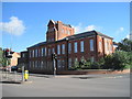
Newark Old Hospital
The building was designed by Bliss and Saunders, and built in red brick by Smith and Lunn. Opened in 1881, it closed in 1996 when a new hospital was built nearby.
Image: © Julian P Guffogg
Taken: 1 Jul 2012
0.09 miles