IMAGES TAKEN NEAR TO
Bailey Road, NEWARK, NG24 4EW
Introduction
This page details the photographs taken nearby to Bailey Road, NG24 4EW by members of the Geograph project.
The Geograph project started in 2005 with the aim of publishing, organising and preserving representative images for every square kilometre of Great Britain, Ireland and the Isle of Man.

There are currently over 7.5m images from over14,400 individuals and you can help contribute to the project by visiting https://www.geograph.org.uk
Image Map
Images are licensed for reuse under creativecommons.org/licenses/by-sa/2.0
Notes
- Clicking on the map will re-center to the selected point.
- The higher the marker number, the further away the image location is from the centre of the postcode.
Image Listing (20 Images Found)
Images are licensed for reuse under creativecommons.org/licenses/by-sa/2.0
Image
Details
Distance
1
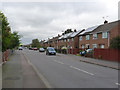
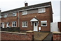
Bailey Road
Part of the post-war section of the large Hawtonville estate to the south of the town.
Image: © Alan Murray-Rust
Taken: 4 Sep 2012
0.03 miles
2
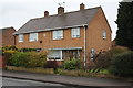
Nos. 2A/2B Bailey Road
There is an OS benchmark Image on the near corner, right hand face, of the right hand face
Image: © Roger Templeman
Taken: 2 May 2016
0.05 miles
3
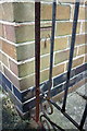
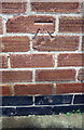
Benchmark on #2A Bailey Road
Ordnance Survey cut mark benchmark described on the Bench Mark Database at http://www.bench-marks.org.uk/bm75322
Image: © Roger Templeman
Taken: 2 May 2016
0.06 miles
4
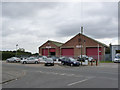
Former bus garage, Bowbridge Road
This was for many years the home of the local bus operator W.Gash & Sons whose two-tone green buses were a familiar sight on the Newark to Nottingham run. With deregulation in 1986, the firm endeavoured to expand by competing with the existing operator on local services within Newark. This eventually proved an unsuccessful venture, and the firm sold out to Lincs Road Car in 1989.
The building is now in industrial use.
Image: © Alan Murray-Rust
Taken: 4 Sep 2012
0.08 miles
5
Benchmark on #22 Trinity Road
Ordnance Survey cut mark benchmark described on the Bench Mark Database at http://www.bench-marks.org.uk/bm75321
Image: © Roger Templeman
Taken: 2 May 2016
0.09 miles
6
Block of houses on Trinity Road
There is an OS benchmark Image on the front of the right hand house, left of the white gate
Image: © Roger Templeman
Taken: 2 May 2016
0.09 miles
7
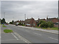
Bowbridge Road
The residential side of the road, looking south.
Image: © Alan Murray-Rust
Taken: 4 Sep 2012
0.12 miles
8
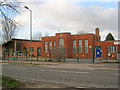
Oliver Quibell Community Infant School
On the west side of Bowbridge Road and, I assume, named after the famous industrialist and former mayor of Newark.
http://www.oliverquibell.co.uk/
Image: © Trevor Rickard
Taken: 22 Jan 2012
0.13 miles
9
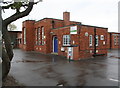
Hawtonville Children's Centre, Bowbridge Road
Image: © phil Richards
Taken: 2 May 2016
0.15 miles
10
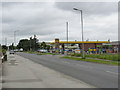
Jet filling station, Bowbridge Road
Bowbridge Road appears to be a main road out of the town, but in practice does not lead to anywhere of importance.
Image: © Alan Murray-Rust
Taken: 4 Sep 2012
0.15 miles