IMAGES TAKEN NEAR TO
Barker Way, Boundary Road, NEWARK, NG24 4BF
Introduction
This page details the photographs taken nearby to Barker Way, Boundary Road, NG24 4BF by members of the Geograph project.
The Geograph project started in 2005 with the aim of publishing, organising and preserving representative images for every square kilometre of Great Britain, Ireland and the Isle of Man.

There are currently over 7.5m images from over14,400 individuals and you can help contribute to the project by visiting https://www.geograph.org.uk
Image Map
Images are licensed for reuse under creativecommons.org/licenses/by-sa/2.0
Notes
- Clicking on the map will re-center to the selected point.
- The higher the marker number, the further away the image location is from the centre of the postcode.
Image Listing (96 Images Found)
Images are licensed for reuse under creativecommons.org/licenses/by-sa/2.0
Image
Details
Distance
1
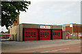
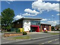
Newark fire station
Newark fire station, Boundary Road, Newark, Nottinghamshire
Image: © Kevin Hale
Taken: 31 May 2008
0.01 miles
2
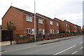
Houses on Boundary Road on site of former barracks
There are still War Department boundary stones eg Image embedded in the roadside wall
Image: © phil Richards
Taken: 2 May 2016
0.03 miles
3

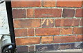
Cut Mark 2 Dunholme Ave Newark on Trent
Image: © Monica Stagg
Taken: 7 Sep 2015
0.03 miles
4
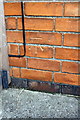
Benchmark on #2 Dunholme Avenue
Ordnance Survey cut mark benchmark described on the Bench Mark Database at http://www.bench-marks.org.uk/bm70239
Image: © Roger Templeman
Taken: 2 May 2016
0.03 miles
5
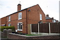
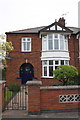
#2 Dunholme Avenue at Boundary Road junction
There is an OS benchmark Image on the side of the house just through the wooden gate
Image: © Roger Templeman
Taken: 2 May 2016
0.03 miles
6
Newark Fire Station, Boundary Road
Built 2017 as a replacement for the older building on the same site https://www.geograph.org.uk/photo/835936
Image: © Alan Murray-Rust
Taken: 19 Jul 2024
0.03 miles
7
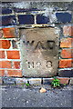
War Department boundary stone, Boundary Road
Marks the boundary of the former barracks, now replaced by housing Image
The stone has Milestone Society National ID: NT_NEWA01em
Image: © Roger Templeman
Taken: 2 May 2016
0.07 miles
8
Benchmark on #56 Boundary Road
Ordnance Survey cut mark benchmark described on the Bench Mark Database at http://www.bench-marks.org.uk/bm70243
Image: © Roger Templeman
Taken: 2 May 2016
0.08 miles
9
#56 Boundary Road
There is an OS benchmark Image on the front of the house near the left hand corner
Image: © Roger Templeman
Taken: 2 May 2016
0.08 miles
10
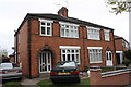
Nos 2 and 4 Windsor Avenue
There is an OS benchmark Image on the side of the left hand house near the front corner beside the grey car
Image: © Roger Templeman
Taken: 2 May 2016
0.08 miles