IMAGES TAKEN NEAR TO
Newark Road, NEWARK, NG24 3RR
Introduction
This page details the photographs taken nearby to Newark Road, NG24 3RR by members of the Geograph project.
The Geograph project started in 2005 with the aim of publishing, organising and preserving representative images for every square kilometre of Great Britain, Ireland and the Isle of Man.

There are currently over 7.5m images from over14,400 individuals and you can help contribute to the project by visiting https://www.geograph.org.uk
Image Map
Images are licensed for reuse under creativecommons.org/licenses/by-sa/2.0
Notes
- Clicking on the map will re-center to the selected point.
- The higher the marker number, the further away the image location is from the centre of the postcode.
Image Listing (50 Images Found)
Images are licensed for reuse under creativecommons.org/licenses/by-sa/2.0
Image
Details
Distance
1
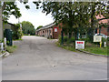
Willow Farm, Hawton
The farmyard is still in use, but many of the buildings have been let out to small businesses.
Image: © Alan Murray-Rust
Taken: 4 Sep 2012
0.02 miles
2
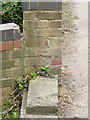
Bench mark, Middle Beck bridge
A clear cut mark on the western parapet http://www.geograph.org.uk/photo/3128767 .
Image: © Alan Murray-Rust
Taken: 4 Sep 2012
0.04 miles
3
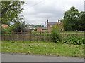
Willow Farm, Hawton
The most northerly of the farms in the village.
Image: © Alan Murray-Rust
Taken: 4 Sep 2012
0.05 miles
4
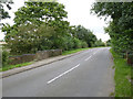
Newark Road, Hawton
The bridge crossing Middle Beck. There is a bench mark on the nearer end of the parapet.
Image: © Alan Murray-Rust
Taken: 4 Sep 2012
0.06 miles
5
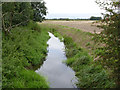
Hawton, Notts.
Middle Beck joins the River Devon (pronounced Deevon) a mile or so ahead. The beck is viewed here from the side of the Cotham-Newark road, travelling towards Newark, with All Saints Church, Hawton approximately 3-4 minutes behind the photographer. The new A46 road to Newark also lies ahead, as does Farndon on the other side of this busy dual carriageway.
Image: © David Hallam-Jones
Taken: 10 Jan 2016
0.06 miles
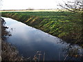
6
Middle Beck, Hawton
Looking west from Newark Road. The stream joins the River Devon.
Image: © Alan Murray-Rust
Taken: 4 Sep 2012
0.06 miles
8
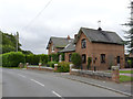
School Cottage
The former village school. A large building for a village which consisted of no more than 3 or 4 farms, a couple of largish houses (including the rectory) and a handful of workers cottages.
Image: © Alan Murray-Rust
Taken: 4 Sep 2012
0.14 miles
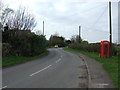
9
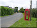
Hawton telephone kiosk
This has suffered from the closeness of the nearby Hawtonville estate. Although the telephone equipment survives, every single pane of glass had been smashed.
Image: © Alan Murray-Rust
Taken: 4 Sep 2012
0.16 miles
10
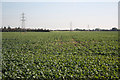
Hawton farmland
Currently agricultural land near Hawton
Image: © Richard Croft
Taken: 22 Oct 2011
0.17 miles