IMAGES TAKEN NEAR TO
Simpson Close, NEWARK, NG24 3RD
Introduction
This page details the photographs taken nearby to Simpson Close, NG24 3RD by members of the Geograph project.
The Geograph project started in 2005 with the aim of publishing, organising and preserving representative images for every square kilometre of Great Britain, Ireland and the Isle of Man.

There are currently over 7.5m images from over14,400 individuals and you can help contribute to the project by visiting https://www.geograph.org.uk
Image Map
Images are licensed for reuse under creativecommons.org/licenses/by-sa/2.0
Notes
- Clicking on the map will re-center to the selected point.
- The higher the marker number, the further away the image location is from the centre of the postcode.
Image Listing (29 Images Found)
Images are licensed for reuse under creativecommons.org/licenses/by-sa/2.0
Image
Details
Distance
1
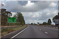
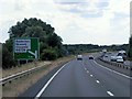
A1 bypassing Newark
Newark has dropped off the mileage signs, but Lincoln and Sleaford have appeared. These are both well off the A1 and reached via the exit just north of Newark.
Image: © Robin Webster
Taken: 7 Oct 2011
0.04 miles
2
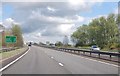
A1 at Balderton
41 Miles to Doncaster.
Image: © Julian P Guffogg
Taken: 4 May 2013
0.07 miles
3
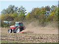
Harrowing
A tractor and power harrow at work off Spring Lane
Image: © Richard Croft
Taken: 30 Sep 2011
0.07 miles
4
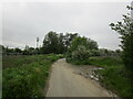
Hollowdyke Lane
Once a through road now truncated by the develoment of Fernwood.
Image: © Jonathan Thacker
Taken: 12 May 2023
0.09 miles
5
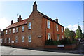
Junction of Main Street and Wetsyke Lane
There is an OS benchmark Image on the Wetsyke Lane face of the corner house about 8ft. from its junction with its front garden wall
Image: © Roger Templeman
Taken: 2 Oct 2016
0.11 miles
6
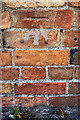
Benchmark on #96 Main Street
Ordnance Survey cut mark benchmark described on the Bench Mark Database at http://www.bench-marks.org.uk/bm79408
Image: © Roger Templeman
Taken: 2 Oct 2016
0.11 miles
8
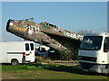
Lightning in scrap yard by the A1
It's really a 1950s UK fighter but it looks like an illustration of some kind of underground exploration machine for an H G Wells novel, as it bursts back to the surface.
Image: © John Goldsmith
Taken: 29 Mar 2009
0.14 miles
9
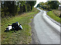
Spring Lane
Flytipped rubbish on Spring Lane
Image: © Richard Croft
Taken: 30 Sep 2011
0.14 miles
10
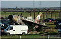
Striking Lightning beside the A1
This aircraft, visible from the A1, is in a scrap yard off Spring Lane near Twitch Farm, Balderton, and has been repeatedly covered on Geograph with the result that its deteriorating state is well documented. It looks as if the shed behind has been short of roof and sides for a very long while.
The church spire appears to be at Claypole.
Image: © John Goldsmith
Taken: 29 Mar 2009
0.15 miles