IMAGES TAKEN NEAR TO
Brooke Close, NEWARK, NG24 3QN
Introduction
This page details the photographs taken nearby to Brooke Close, NG24 3QN by members of the Geograph project.
The Geograph project started in 2005 with the aim of publishing, organising and preserving representative images for every square kilometre of Great Britain, Ireland and the Isle of Man.

There are currently over 7.5m images from over14,400 individuals and you can help contribute to the project by visiting https://www.geograph.org.uk
Image Map
Images are licensed for reuse under creativecommons.org/licenses/by-sa/2.0
Notes
- Clicking on the map will re-center to the selected point.
- The higher the marker number, the further away the image location is from the centre of the postcode.
Image Listing (12 Images Found)
Images are licensed for reuse under creativecommons.org/licenses/by-sa/2.0
Image
Details
Distance
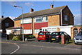
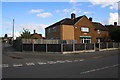
1
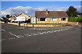
Bungalow at Brooke Close / Macaulay Drive junction
Image: © phil Richards
Taken: 2 Oct 2016
0.05 miles
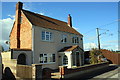
4
Wordsworth Drive, Balderton
The 1960s era housing on this estate, where all the roads are somewhat unimaginatively named after poets, were built as Balderton turned from being a village into a suburb of Newark on Trent.
Image: © Stephen McKay
Taken: 24 Mar 2023
0.15 miles
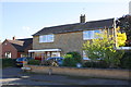
5
Nos. 26 and 28 Goldsmith Road
The original boundary wall of the right hand house has been removed to facilitate parking
Image: © phil Richards
Taken: 2 Oct 2016
0.17 miles
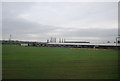
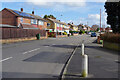
9
Junction in Warwick Road
The house at the corner (#64) appears to have been extended
Image: © phil Richards
Taken: 2 Oct 2016
0.24 miles
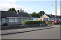
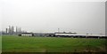
10
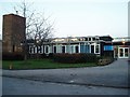
Grove Comprehensive School, Balderton
I am proud to say that I was a pupil there!
Image: © Geoff Dunn
Taken: 7 Feb 2006
0.24 miles