IMAGES TAKEN NEAR TO
Manthorpe Way, NEWARK, NG24 3PP
Introduction
This page details the photographs taken nearby to Manthorpe Way, NG24 3PP by members of the Geograph project.
The Geograph project started in 2005 with the aim of publishing, organising and preserving representative images for every square kilometre of Great Britain, Ireland and the Isle of Man.

There are currently over 7.5m images from over14,400 individuals and you can help contribute to the project by visiting https://www.geograph.org.uk
Image Map
Images are licensed for reuse under creativecommons.org/licenses/by-sa/2.0
Notes
- Clicking on the map will re-center to the selected point.
- The higher the marker number, the further away the image location is from the centre of the postcode.
Image Listing (61 Images Found)
Images are licensed for reuse under creativecommons.org/licenses/by-sa/2.0
Image
Details
Distance
1
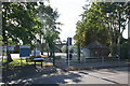
Entrance to The Chuter Ede School from Wolfit Avenue
There is an OS benchmark Image on the near corner, right hand face, of the small brick building on the right hand side of the image
Image: © Roger Templeman
Taken: 2 Oct 2016
0.12 miles
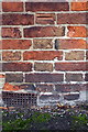
2
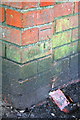
Benchmark on small building at Chuter Ede School
Ordnance Survey cut mark benchmark described on the Bench Mark Database at http://www.bench-marks.org.uk/bm79505
Image: © Roger Templeman
Taken: 2 Oct 2016
0.12 miles
3
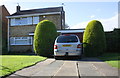
#41 Bullpit Road
There is an OS benchmark Image on the right hand side of the garage at its front corner
Image: © Roger Templeman
Taken: 2 Oct 2016
0.13 miles
4
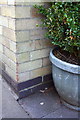
Benchmark on garage of #41 Bullpit Road
Ordnance Survey cut mark benchmark described on the Bench Mark Database at http://www.bench-marks.org.uk/bm79506
Image: © Roger Templeman
Taken: 2 Oct 2016
0.13 miles
5
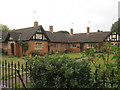
Almshouses, Main Street, Balderton
Built and endowed at the bequest of Alice Bakewell of the Old Hall Balderton 1889.
Image: © Jonathan Thacker
Taken: 13 Aug 2010
0.14 miles
7
Benchmark on #86 Main Street
Ordnance Survey cut mark benchmark described on the Bench Mark Database at http://www.bench-marks.org.uk/bm79409
Image: © Roger Templeman
Taken: 2 Oct 2016
0.15 miles
8
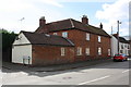
#86 Main Street, 'Stable Cottage'
There is an OS benchmark Image on the front of the house
Image: © Roger Templeman
Taken: 2 Oct 2016
0.15 miles
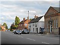
9
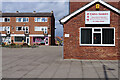
Brisbane Court, Balderton
Like the surrounding housing development this small shopping precinct dates from the 1960s. In those days there would probably have been a selection of shops selling basic necessities including possibly a butchers, greengrocers and newsagents. In the era of supermarkets and convenience stores, such a range of separate shops is hardly ever necessary and different sorts of retailers have come in to fill the gaps. In this view there is China Garden, selling take away Chinese food, a gift card shop and a pet store.
Image: © Stephen McKay
Taken: 24 Mar 2023
0.16 miles
10
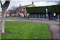
Wolfit Avenue, Balderton
Wolfit Avenue leads off Main Street to the west of the old village centre. The bus stop is served by a regular Stagecoach route into Newark on Trent.
Image: © Stephen McKay
Taken: 24 Mar 2023
0.16 miles