IMAGES TAKEN NEAR TO
Pinfold Lane, NEWARK, NG24 3LP
Introduction
This page details the photographs taken nearby to Pinfold Lane, NG24 3LP by members of the Geograph project.
The Geograph project started in 2005 with the aim of publishing, organising and preserving representative images for every square kilometre of Great Britain, Ireland and the Isle of Man.

There are currently over 7.5m images from over14,400 individuals and you can help contribute to the project by visiting https://www.geograph.org.uk
Image Map
Images are licensed for reuse under creativecommons.org/licenses/by-sa/2.0
Notes
- Clicking on the map will re-center to the selected point.
- The higher the marker number, the further away the image location is from the centre of the postcode.
Image Listing (74 Images Found)
Images are licensed for reuse under creativecommons.org/licenses/by-sa/2.0
Image
Details
Distance
1
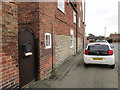
Lias walling in former farmhouse, Pinfold Lane, Balderton
Some of the farm buildings still remain though the land was built over with housing in the 1960s.
Image: © Jonathan Thacker
Taken: 28 Jan 2020
0.01 miles
2
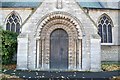
Norman Doorway
A particularly fine Norman north doorway to St.Giles' church, Balderton
Image: © Richard Croft
Taken: 19 Nov 2006
0.03 miles
3

Footpath from Pinfold Lane to Church Lane, Balderton
Image: © Jonathan Thacker
Taken: 28 Jan 2020
0.04 miles
5
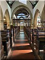
Interior - Balderton, St Giles Church
Image: © thejackrustles
Taken: 8 Oct 2021
0.06 miles
6
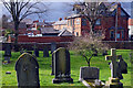
Balderton Churchyard
The sky looks threatening over the churchyard outside St Giles' church. The large building on the right is Chesters pub.
Image: © Stephen McKay
Taken: 24 Mar 2023
0.07 miles
7
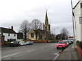
Pinfold Lane, Balderton
Pinfold Lane runs along the side of the churchyard from which it is separated by a wall. Ahead is Chesters, one of two pubs in the old village. It was built in 1888, then known as the Cock Inn.
Image: © Stephen McKay
Taken: 24 Mar 2023
0.07 miles
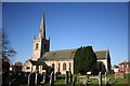
8
St. Giles Church, Balderton
View from the east.
Image: © Peter Langsdale
Taken: Unknown
0.08 miles
9
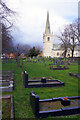
Balderton Churchyard
Looking across the large churchyard to the spire of St Giles' church.
Image: © Stephen McKay
Taken: 24 Mar 2023
0.08 miles
10
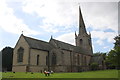
St Giles's Church
The spire is an Ordnance Survey intersected station trig point, see http://trigpointing.uk/trig/12326
Image: © Roger Templeman
Taken: 2 Oct 2016
0.08 miles