IMAGES TAKEN NEAR TO
Grange Lane, NEWARK, NG24 3JJ
Introduction
This page details the photographs taken nearby to Grange Lane, NG24 3JJ by members of the Geograph project.
The Geograph project started in 2005 with the aim of publishing, organising and preserving representative images for every square kilometre of Great Britain, Ireland and the Isle of Man.

There are currently over 7.5m images from over14,400 individuals and you can help contribute to the project by visiting https://www.geograph.org.uk
Image Map
Images are licensed for reuse under creativecommons.org/licenses/by-sa/2.0
Notes
- Clicking on the map will re-center to the selected point.
- The higher the marker number, the further away the image location is from the centre of the postcode.
Image Listing (7 Images Found)
Images are licensed for reuse under creativecommons.org/licenses/by-sa/2.0
Image
Details
Distance
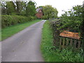

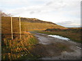
4
Grange Lane
Towards Balderton Grange on the right.
Image: © J.Hannan-Briggs
Taken: 5 Jun 2016
0.08 miles
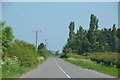
5
Fields reclaimed from Staple Quarry
The trees mark Balderton Grange. The spoil heap is from active workings at Bantycock Quarry.
Image: © Jonathan Thacker
Taken: 21 Nov 2020
0.15 miles
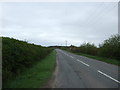
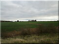
6
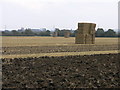
Rare Square Bales
The now usual round bales have not made it to this field yet.
Image: © Michael Patterson
Taken: 14 Sep 2006
0.19 miles
7
Spoil Heap near Grange Lane
Part of a large gypsum quarry.
Image: © Jonathan Thacker
Taken: 26 Feb 2011
0.25 miles