IMAGES TAKEN NEAR TO
Gilmores Lane, NEWARK, NG24 3GX
Introduction
This page details the photographs taken nearby to Gilmores Lane, NG24 3GX by members of the Geograph project.
The Geograph project started in 2005 with the aim of publishing, organising and preserving representative images for every square kilometre of Great Britain, Ireland and the Isle of Man.

There are currently over 7.5m images from over14,400 individuals and you can help contribute to the project by visiting https://www.geograph.org.uk
Image Map
Images are licensed for reuse under creativecommons.org/licenses/by-sa/2.0
Notes
- Clicking on the map will re-center to the selected point.
- The higher the marker number, the further away the image location is from the centre of the postcode.
Image Listing (15 Images Found)
Images are licensed for reuse under creativecommons.org/licenses/by-sa/2.0
Image
Details
Distance
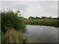
1
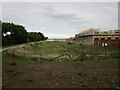
Run-off catchment area and new housing alongside Hollowdyke Lane, Fernwood
Image: © Jonathan Thacker
Taken: 18 Sep 2022
0.09 miles
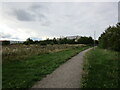
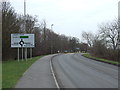
3
New development near Fernwood
Position of camera and subject somewhat approximate. I will correct them when OS mapping catches up.
Image: © Jonathan Thacker
Taken: 18 Sep 2022
0.15 miles
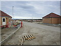
4
New housing under construction
The southward expansion of Fernwood.
Image: © Jonathan Thacker
Taken: 2 Dec 2021
0.16 miles
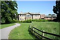
6
Balderton Hall
It is in the grounds of Balderton Hall that the new suburb of Fernwood is being developed.
Image: © Jonathan Thacker
Taken: 5 Aug 2011
0.17 miles
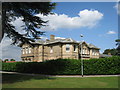
7
Balderton Hall
Built in 1840 for local banker Thomas Spragging Godfrey, it served as a family home until 1936 when work started on building a hospital in the parkland. It was officer's accommodation for RAF Balderton during the war and in October 1957 it became the administrative block of the hospital for patients with learning disabilities until it closed in 1993.
It is currently offices in a large development of over 1,000 new homes on the former hospital site.
Image: © Richard Croft
Taken: 4 Jun 2008
0.18 miles
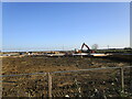
8
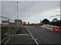
Construction of a new roundabout near Fernwood
Image: © Jonathan Thacker
Taken: 18 Sep 2022
0.18 miles
10
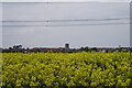
Fernwood Tower across a field of Oilseed Rape.
Land set to disappear under the spread of Suburbia.
Image: © David White
Taken: 18 May 2012
0.19 miles