IMAGES TAKEN NEAR TO
Jericho Road, NEWARK, NG24 3GT
Introduction
This page details the photographs taken nearby to Jericho Road, NG24 3GT by members of the Geograph project.
The Geograph project started in 2005 with the aim of publishing, organising and preserving representative images for every square kilometre of Great Britain, Ireland and the Isle of Man.

There are currently over 7.5m images from over14,400 individuals and you can help contribute to the project by visiting https://www.geograph.org.uk
Image Map
Images are licensed for reuse under creativecommons.org/licenses/by-sa/2.0
Notes
- Clicking on the map will re-center to the selected point.
- The higher the marker number, the further away the image location is from the centre of the postcode.
Image Listing (14 Images Found)
Images are licensed for reuse under creativecommons.org/licenses/by-sa/2.0
Image
Details
Distance
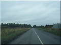
1
Staple Lane
Closed to allow for the construction of the Newark Southern Link Road.
Image: © Jonathan Thacker
Taken: 14 Jul 2024
0.10 miles
2
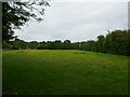
Grass field with buttercups off Staple Lane
Image: © Jonathan Thacker
Taken: 14 Jul 2024
0.14 miles
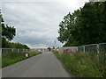
3
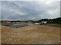
New roundabour under construction
The eastern end of the Newark Southern Link Road.
Image: © Jonathan Thacker
Taken: 14 Jul 2024
0.16 miles
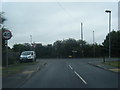
4
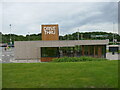
Starbucks Drive Thru, Newark Services
Image: © Jonathan Thacker
Taken: 14 Jul 2024
0.18 miles
6
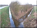
Junction of ditches alongside Staple Lane
Image: © Jonathan Thacker
Taken: 26 Feb 2011
0.19 miles
7
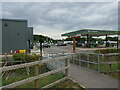
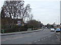
Pedestrian entrance t0 Newark Services
Image: © Jonathan Thacker
Taken: 14 Jul 2024
0.19 miles