IMAGES TAKEN NEAR TO
Centenary Close, NEWARK, NG24 3FE
Introduction
This page details the photographs taken nearby to Centenary Close, NG24 3FE by members of the Geograph project.
The Geograph project started in 2005 with the aim of publishing, organising and preserving representative images for every square kilometre of Great Britain, Ireland and the Isle of Man.

There are currently over 7.5m images from over14,400 individuals and you can help contribute to the project by visiting https://www.geograph.org.uk
Image Map
Images are licensed for reuse under creativecommons.org/licenses/by-sa/2.0
Notes
- Clicking on the map will re-center to the selected point.
- The higher the marker number, the further away the image location is from the centre of the postcode.
Image Listing (30 Images Found)
Images are licensed for reuse under creativecommons.org/licenses/by-sa/2.0
Image
Details
Distance
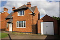
1
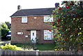
#43 Hawton Lane
There is an OS benchmark Image on the front of the house at its left hand corner
Image: © Roger Templeman
Taken: 2 Oct 2016
0.07 miles
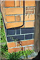
2
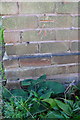
Benchmark on #43 Hawton Lane
Ordnance Survey cut mark benchmark described on the Bench Mark Database at http://www.bench-marks.org.uk/bm79502
Image: © Roger Templeman
Taken: 2 Oct 2016
0.07 miles
3
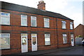
Houses on Hawton Lane
There is an OS benchmark Image to the right of the door of the end house, next to the wooden fence
Image: © Roger Templeman
Taken: 2 Oct 2016
0.08 miles
4
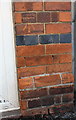
Benchmark on #15 Hawton Lane
Ordnance Survey cut mark benchmark described on the Bench Mark Database at http://www.bench-marks.org.uk/bm79501
Image: © Roger Templeman
Taken: 2 Oct 2016
0.08 miles
5
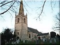
St Giles Church, Balderton
The simple 12th century church was enlarged in the 13th century with a new chancel whilst the aisles were added in the 14th century. The rood screen dates from about 1475. The church was restored in the 19th century when the clerestory was removed.
Image: © Geoff Dunn
Taken: 7 Feb 2006
0.13 miles
6
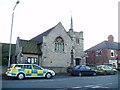
Balderton Methodist Church
In front of the Church is a Memorial to the dead of the two World Wars.
Image: © Geoff Dunn
Taken: 7 Feb 2006
0.13 miles
7
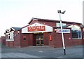
Turks Head Public House, London Road, Balderton
Image: © Geoff Dunn
Taken: 7 Feb 2006
0.13 miles
9
Benchmark on #197 London Road
Ordnance Survey cut mark benchmark described on the Bench Mark Database at http://www.bench-marks.org.uk/bm79500
Image: © Roger Templeman
Taken: 2 Oct 2016
0.15 miles
10
#197 London Road
There is an OS benchmark Image on the near corner, beside the wooden gate, of the former police station
Image: © Roger Templeman
Taken: 2 Oct 2016
0.15 miles