IMAGES TAKEN NEAR TO
Orchid Close, NEWARK, NG24 3ET
Introduction
This page details the photographs taken nearby to Orchid Close, NG24 3ET by members of the Geograph project.
The Geograph project started in 2005 with the aim of publishing, organising and preserving representative images for every square kilometre of Great Britain, Ireland and the Isle of Man.

There are currently over 7.5m images from over14,400 individuals and you can help contribute to the project by visiting https://www.geograph.org.uk
Image Map
Images are licensed for reuse under creativecommons.org/licenses/by-sa/2.0
Notes
- Clicking on the map will re-center to the selected point.
- The higher the marker number, the further away the image location is from the centre of the postcode.
Image Listing (50 Images Found)
Images are licensed for reuse under creativecommons.org/licenses/by-sa/2.0
Image
Details
Distance
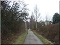
2
National Cycle Route 64
Heading south along the course of the old GNR railway line to Bottesford.
Image: © Trevor Rickard
Taken: 22 Jan 2012
0.06 miles
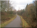
3
Cyclists on the national cycle route 64
Heading north towards the London Road.
Image: © Christine Johnstone
Taken: 18 Jan 2014
0.07 miles
4
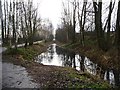
Flooded railway route, near Balderton Lake
The national cycle route 64 shifts eastward here, by a couple of metres.
Image: © Christine Johnstone
Taken: 18 Jan 2014
0.11 miles
5
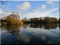
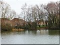
Balderton Lake
Balderton Lake and its surrounds is a former gravel pit now maintained as a local amenity.
Image: © Jonathan Thacker
Taken: 5 Dec 2020
0.11 miles
6
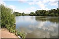
Balderton Lake
Lake formed after aggregate extraction at Balderton
Image: © Richard Croft
Taken: 14 Aug 2008
0.13 miles
7
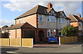
Houses at the bend in Bancroft Road
There is an OS benchmark Image on the front of the near house between its garage and front door
Image: © Roger Templeman
Taken: 2 Oct 2016
0.14 miles
8
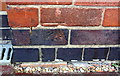
Benchmark on #44 Bancroft Road
Ordnance Survey cut mark benchmark described on the Bench Mark Database at http://www.bench-marks.org.uk/bm79512
Image: © Roger Templeman
Taken: 2 Oct 2016
0.14 miles
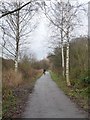
9
Houses in Rowan Way
On the north-east bank of Balderton Lake, a flooded gravel pit.
Image: © Christine Johnstone
Taken: 18 Jan 2014
0.14 miles
10
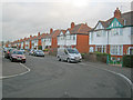
Bancroft Road
Looking northwards along a row of semi-detached houses. Classic well-built 1930s architecture here with the circular front door alcoves, bay windows and mock-Tudor gables.
Image: © Trevor Rickard
Taken: 22 Jan 2012
0.15 miles