IMAGES TAKEN NEAR TO
Stirling Drive, NEWARK, NG24 2TB
Introduction
This page details the photographs taken nearby to Stirling Drive, NG24 2TB by members of the Geograph project.
The Geograph project started in 2005 with the aim of publishing, organising and preserving representative images for every square kilometre of Great Britain, Ireland and the Isle of Man.

There are currently over 7.5m images from over14,400 individuals and you can help contribute to the project by visiting https://www.geograph.org.uk
Image Map
Images are licensed for reuse under creativecommons.org/licenses/by-sa/2.0
Notes
- Clicking on the map will re-center to the selected point.
- The higher the marker number, the further away the image location is from the centre of the postcode.
Image Listing (11 Images Found)
Images are licensed for reuse under creativecommons.org/licenses/by-sa/2.0
Image
Details
Distance
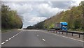
4
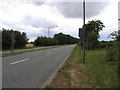
A1 - turn off for Coddington
But only if your vehicle is less than 7.5 t.
Image: © Robin Webster
Taken: 7 Oct 2011
0.16 miles
5
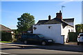
'Enfin', #43 Newark Road
The road face of the building has been cement rendered
Image: © phil Richards
Taken: 3 Oct 2016
0.16 miles
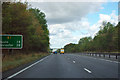
6
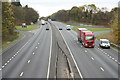
A1 north
View north from Beckingham Road bridge
Image: © Richard Croft
Taken: 31 Oct 2011
0.17 miles
9
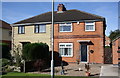
Nos. 171 and 172 Beacon Hill Road
The left hand house has had cladding applied
Image: © phil Richards
Taken: 3 Oct 2016
0.25 miles
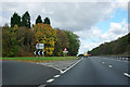
10
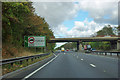
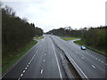
A1 - Beckingham Road bridge
Connections to and from the A1 are beyond the bridge.
Image: © Robin Webster
Taken: 7 Oct 2011
0.25 miles