IMAGES TAKEN NEAR TO
Syerston Way, NEWARK, NG24 2SU
Introduction
This page details the photographs taken nearby to Syerston Way, NG24 2SU by members of the Geograph project.
The Geograph project started in 2005 with the aim of publishing, organising and preserving representative images for every square kilometre of Great Britain, Ireland and the Isle of Man.

There are currently over 7.5m images from over14,400 individuals and you can help contribute to the project by visiting https://www.geograph.org.uk
Image Map
Images are licensed for reuse under creativecommons.org/licenses/by-sa/2.0
Notes
- Clicking on the map will re-center to the selected point.
- The higher the marker number, the further away the image location is from the centre of the postcode.
Image Listing (18 Images Found)
Images are licensed for reuse under creativecommons.org/licenses/by-sa/2.0
Image
Details
Distance
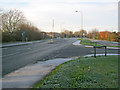
1
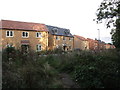
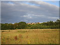
Autumn Croft Road, Newark
A modern estate on the east side of Newark.
Image: © Julian P Guffogg
Taken: 3 Mar 2016
0.10 miles
3
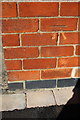
Benchmark on #107 Beacon Hill Road
Ordnance Survey cut mark benchmark described on the Bench Mark Database at http://www.bench-marks.org.uk/bm79604
Image: © Roger Templeman
Taken: 3 Oct 2016
0.12 miles
4
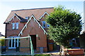
#158 Beacon Hill Road, extended east end
Image: © phil Richards
Taken: 3 Oct 2016
0.12 miles
5
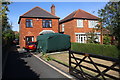
Nos. 107 and 109 Beacon Hill Road
There is an OS benchmark Image on the front, left hand corner, of the left hand house, behind a plant in a pot
Image: © Roger Templeman
Taken: 3 Oct 2016
0.13 miles
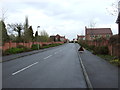
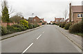
7
Beacon Hill Road
Looking west at the junction with Autumn Croft Road.
Image: © Trevor Rickard
Taken: 10 Dec 2011
0.16 miles