IMAGES TAKEN NEAR TO
Newark Lane, NEWARK, NG24 2SL
Introduction
This page details the photographs taken nearby to Newark Lane, NG24 2SL by members of the Geograph project.
The Geograph project started in 2005 with the aim of publishing, organising and preserving representative images for every square kilometre of Great Britain, Ireland and the Isle of Man.

There are currently over 7.5m images from over14,400 individuals and you can help contribute to the project by visiting https://www.geograph.org.uk
Image Map
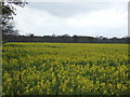
Images are licensed for reuse under creativecommons.org/licenses/by-sa/2.0
Notes
- Clicking on the map will re-center to the selected point.
- The higher the marker number, the further away the image location is from the centre of the postcode.
Image Listing (20 Images Found)
Images are licensed for reuse under creativecommons.org/licenses/by-sa/2.0
Image
Details
Distance
1
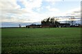
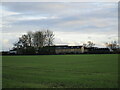
Autumn sown crop
Grange Farm hidden by the trees in the centre of the picture.
Image: © Jonathan Thacker
Taken: 24 Dec 2020
0.01 miles
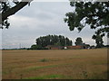
3
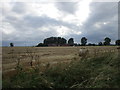
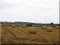
Harvested field and Grange Farm
A storm brewing.
Image: © Jonathan Thacker
Taken: 30 Jul 2019
0.02 miles