IMAGES TAKEN NEAR TO
Balderton Lane, NEWARK, NG24 2QD
Introduction
This page details the photographs taken nearby to Balderton Lane, NG24 2QD by members of the Geograph project.
The Geograph project started in 2005 with the aim of publishing, organising and preserving representative images for every square kilometre of Great Britain, Ireland and the Isle of Man.

There are currently over 7.5m images from over14,400 individuals and you can help contribute to the project by visiting https://www.geograph.org.uk
Image Map
Images are licensed for reuse under creativecommons.org/licenses/by-sa/2.0
Notes
- Clicking on the map will re-center to the selected point.
- The higher the marker number, the further away the image location is from the centre of the postcode.
Image Listing (16 Images Found)
Images are licensed for reuse under creativecommons.org/licenses/by-sa/2.0
Image
Details
Distance
3
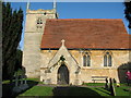
All Saints Church Coddington
13th century church which had extensive restoration in 1864.
Image: © Bob Danylec
Taken: 13 Nov 2005
0.18 miles
4
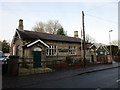
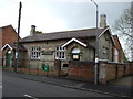
The former National School
Opened in 1846 and in use as a school until the mid 1960s. Now the home of the local Scouts.
Image: © Jonathan Thacker
Taken: 17 Dec 2016
0.20 miles
5
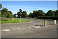
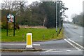
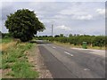
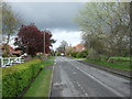
Junction of Newark Road and Beckingham Road
Image: © Roger Templeman
Taken: 3 Oct 2016
0.21 miles
6
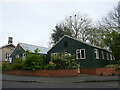
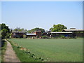
Coddington Village Hall
An active rookery in the trees behind.
Image: © Jonathan Thacker
Taken: 27 Apr 2024
0.21 miles