IMAGES TAKEN NEAR TO
Pocklington Crescent, NEWARK, NG24 2PG
Introduction
This page details the photographs taken nearby to Pocklington Crescent, NG24 2PG by members of the Geograph project.
The Geograph project started in 2005 with the aim of publishing, organising and preserving representative images for every square kilometre of Great Britain, Ireland and the Isle of Man.

There are currently over 7.5m images from over14,400 individuals and you can help contribute to the project by visiting https://www.geograph.org.uk
Image Map
Images are licensed for reuse under creativecommons.org/licenses/by-sa/2.0
Notes
- Clicking on the map will re-center to the selected point.
- The higher the marker number, the further away the image location is from the centre of the postcode.
Image Listing (24 Images Found)
Images are licensed for reuse under creativecommons.org/licenses/by-sa/2.0
Image
Details
Distance
1
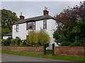
Winthorpe, Gainsborough Road, "Hillcrest"
This house was the location of an Ordnance Survey benchmark dating from 1856 during the First Primary Levelling of England and Wales, being a mark on the Coventry to Lincoln levelling line. See http://www.bench-marks.org.uk/bm23015 for details.
Image: © Brian Westlake
Taken: 20 Oct 2017
0.08 miles
2
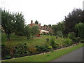
Cottages on Chapel Lane, Winthorpe seen from Holme Lane
Image: © Jonathan Thacker
Taken: 13 Aug 2010
0.14 miles
3
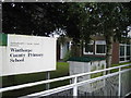
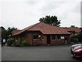
Winthorpe County Primary School
The school is down short road that turns into a track just off the main road through Winthorpe.
Image: © Matthew Smith
Taken: 10 Sep 2005
0.15 miles
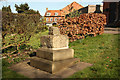
4
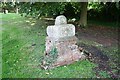
The Priest's Stone
Base of a 14th century cross relocated here in the 1840s and set on a brick plinth, known locally as 'The Priest's Stone'
Image: © Richard Croft
Taken: 14 Aug 2008
0.16 miles
6
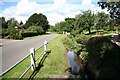
Holme Lane
Lane to Holme and the Fleet re-emerging by the Almshouses in Winthorpe
Image: © Richard Croft
Taken: 14 Aug 2008
0.17 miles
7
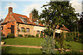
Brewer's Charity Almshouses
Surprisingly un-listed early 17th century former Almshouses on Chapel Lane, now private residences.
Thomas Brewer was a yeoman of Winthorpe in the late 16th and early 17th centuries. He left money, property and land to the village which instituted a charity which still exists today. Rents were gathered from the land, whilst the properties were divided into 5 tenements and gardens (the Almshouses seen here) and occupied free by the poor of the parish.
Image: © Richard Croft
Taken: 17 Jul 2012
0.17 miles
8
The Priest's Stone
Base and part of the shaft of a 14th century preaching cross, recently restored and re-sited in Withorpe http://www.geograph.org.uk/photo/937039
Image: © Richard Croft
Taken: 25 Mar 2012
0.18 miles
9
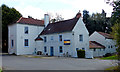
Lord Nelson in Winthorpe
Grade II listed public house on Gainsborough Road, closed and for sale at the time this photo was taken.
Image: © Mat Fascione
Taken: 19 Apr 2016
0.18 miles
10
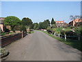
Holme Lane, Winthorpe
Cycle Route 64 starting on its run north from Newark
Image: © Tim Heaton
Taken: 24 Mar 2011
0.18 miles