IMAGES TAKEN NEAR TO
Long Hollow Way, NEWARK, NG24 2NH
Introduction
This page details the photographs taken nearby to Long Hollow Way, NG24 2NH by members of the Geograph project.
The Geograph project started in 2005 with the aim of publishing, organising and preserving representative images for every square kilometre of Great Britain, Ireland and the Isle of Man.

There are currently over 7.5m images from over14,400 individuals and you can help contribute to the project by visiting https://www.geograph.org.uk
Image Map
Images are licensed for reuse under creativecommons.org/licenses/by-sa/2.0
Notes
- Clicking on the map will re-center to the selected point.
- The higher the marker number, the further away the image location is from the centre of the postcode.
Image Listing (10 Images Found)
Images are licensed for reuse under creativecommons.org/licenses/by-sa/2.0
Image
Details
Distance
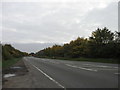
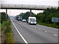
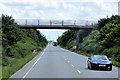
3
A17 heading east
Near Newark Showground.
Image: © J.Hannan-Briggs
Taken: 8 Mar 2015
0.19 miles
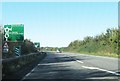
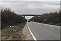
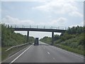
5
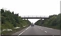
Footbridge over A17 east of Newark
By agricultural showground
Image: © John Firth
Taken: 9 Jun 2013
0.22 miles
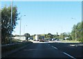
8
Godfrey Drive, Overfield Park
A developing commercial area to the north of Newark. The position of the subject and photographer in this picture are only approximate as OS has not yet mapped this area.
Image: © Jonathan Thacker
Taken: 25 Mar 2019
0.24 miles