IMAGES TAKEN NEAR TO
Barnby Crossing, NEWARK, NG24 2NG
Introduction
This page details the photographs taken nearby to Barnby Crossing, NG24 2NG by members of the Geograph project.
The Geograph project started in 2005 with the aim of publishing, organising and preserving representative images for every square kilometre of Great Britain, Ireland and the Isle of Man.

There are currently over 7.5m images from over14,400 individuals and you can help contribute to the project by visiting https://www.geograph.org.uk
Image Map
Images are licensed for reuse under creativecommons.org/licenses/by-sa/2.0
Notes
- Clicking on the map will re-center to the selected point.
- The higher the marker number, the further away the image location is from the centre of the postcode.
Image Listing (19 Images Found)
Images are licensed for reuse under creativecommons.org/licenses/by-sa/2.0
Image
Details
Distance

4

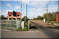
Barnby Crossing
Barnby Lane crosses the East Coast Main Line.
Image: © Jonathan Thacker
Taken: 2 Jan 2021
0.11 miles
5
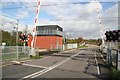
Barnby Crossing
Barnby Road crossing the east coast main line
Image: © Richard Croft
Taken: 16 Oct 2008
0.12 miles
6
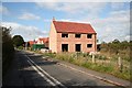
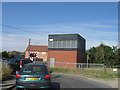
New house on Barnby Road
New house, started but not finished, on Barnby Road, by the level crossing
Image: © Richard Croft
Taken: 16 Oct 2008
0.14 miles
8
Barnby Crossing
Looking north on the East Coast Mainline at Barnby Road
Image: © Richard Croft
Taken: 16 Oct 2008
0.15 miles
9
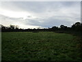
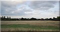
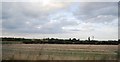
Grass field off Barnby Road
Zoned for housing.
Image: © Jonathan Thacker
Taken: 14 Jan 2023
0.15 miles