IMAGES TAKEN NEAR TO
Yorke Drive, NEWARK, NG24 2HL
Introduction
This page details the photographs taken nearby to Yorke Drive, NG24 2HL by members of the Geograph project.
The Geograph project started in 2005 with the aim of publishing, organising and preserving representative images for every square kilometre of Great Britain, Ireland and the Isle of Man.

There are currently over 7.5m images from over14,400 individuals and you can help contribute to the project by visiting https://www.geograph.org.uk
Image Map
Images are licensed for reuse under creativecommons.org/licenses/by-sa/2.0
Notes
- Clicking on the map will re-center to the selected point.
- The higher the marker number, the further away the image location is from the centre of the postcode.
Image Listing (47 Images Found)
Images are licensed for reuse under creativecommons.org/licenses/by-sa/2.0
Image
Details
Distance
1
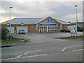
Food stores on Lincoln Road
Local Co-op and pizza shop on the south side of the road.
Image: © Trevor Rickard
Taken: 18 Dec 2011
0.03 miles
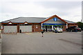
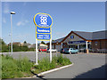
3
Co-op Store in Newark
Located on B6166 Lincoln Road.
Image: © Jonathan Clitheroe
Taken: 14 Oct 2023
0.03 miles
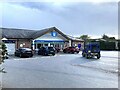
4
Grilliano, Fastan and Co-op store on Lincoln Road
The Bridge Inn formerly occupied this site
Image: © phil Richards
Taken: 1 May 2016
0.03 miles
5
Lincoln Road Co-op foodstore
A new store on the site of the former Bridge Inn.
Image: © Alan Murray-Rust
Taken: 4 Sep 2012
0.04 miles
6

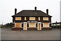
The sign of The Bridge
With the name obscured by the Agent's advert. See http://www.geograph.org.uk/photo/1729265 and http://www.geograph.org.uk/photo/1797498 .
Image: © David Lally
Taken: 7 Apr 2010
0.04 miles
7
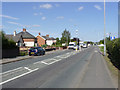
Lincoln Road
The old Fosse Way on its way out of Newark. Traffic is much reduced since the opening of the western bypass carrying the A46.
Image: © Alan Murray-Rust
Taken: 4 Sep 2012
0.05 miles
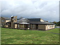
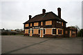
9
St Leonard's Church and Bridge Community Centre
Dedicated in November 1978, it was a replacement for an earlier (1873) church on Northgate. The new location was chosen to better serve the newer estates north of the railway, and the church was built in cooperation with Newark District Council who were responsible for the integrated Community Centre. 'Bridge' refers to the bridge over the East Coast Main Line, a short distance towards town.
Image: © Alan Murray-Rust
Taken: 4 Sep 2012
0.05 miles
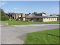
10
The Bridge
Closed, boarded up, vandalised and recently the target of arsonists, The Bridge awaits demolition and the site re-developed
Image: © Richard Croft
Taken: 27 Feb 2010
0.06 miles