IMAGES TAKEN NEAR TO
Rosewood Close, NEWARK, NG24 2HG
Introduction
This page details the photographs taken nearby to Rosewood Close, NG24 2HG by members of the Geograph project.
The Geograph project started in 2005 with the aim of publishing, organising and preserving representative images for every square kilometre of Great Britain, Ireland and the Isle of Man.

There are currently over 7.5m images from over14,400 individuals and you can help contribute to the project by visiting https://www.geograph.org.uk
Image Map
Images are licensed for reuse under creativecommons.org/licenses/by-sa/2.0
Notes
- Clicking on the map will re-center to the selected point.
- The higher the marker number, the further away the image location is from the centre of the postcode.
Image Listing (35 Images Found)
Images are licensed for reuse under creativecommons.org/licenses/by-sa/2.0
Image
Details
Distance
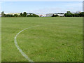
1
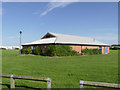
Changing rooms, Lincoln Road sports facility
With four football pitches on the site, a substantial changing facility is necessary.
Image: © Alan Murray-Rust
Taken: 4 Sep 2012
0.04 miles
2
Allotment gardens
Currently shown as such on OS maps, although clearly there have been no allotments here for a number of years.
Image: © Alan Murray-Rust
Taken: 4 Sep 2012
0.10 miles
3
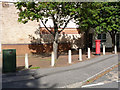
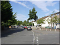
Yorke Drive postbox (ref. NG24 191)
Standard EIIR pillar box serving a post-war council-housing estate.
Image: © Alan Murray-Rust
Taken: 4 Sep 2012
0.10 miles
4
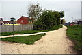
Junction of footpaths beside Newark Business Park
Image: © phil Richards
Taken: 1 May 2016
0.10 miles
5
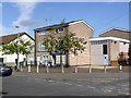
Yorke 1 Foodstore
A small parade of half-a-dozen shops on the corner of Yorke Drive is now reduced to a single unit; the rest have been converted to dwellings.
Image: © Alan Murray-Rust
Taken: 4 Sep 2012
0.11 miles
6
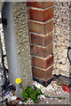
Benchmark at junction of #44 and #46 Strawberry Hall Lane
Ordnance Survey cut mark benchmark described on the Bench Mark Database at http://www.bench-marks.org.uk/bm75283
Image: © Roger Templeman
Taken: 1 May 2016
0.11 miles
7
#44 Strawberry Hall Lane viewed through gateway of #46
There is an OS benchmark Image on the bricks at the junction of the two houses beside a concrete fence post
Image: © Roger Templeman
Taken: 1 May 2016
0.11 miles
8
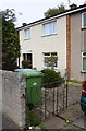
Yorke Drive
The western leg of this road which forms a complete square.
Image: © Alan Murray-Rust
Taken: 4 Sep 2012
0.12 miles
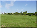
9
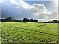
Playing Field in Newark
An industrial estate lies beyond the park.
Image: © Jonathan Clitheroe
Taken: 14 Oct 2023
0.14 miles
10
Lincoln Road sports facility
A major venue for local amateur footballers, with four pitches. Looking towards Brunel Drive industrial area.
Image: © Alan Murray-Rust
Taken: 4 Sep 2012
0.16 miles