IMAGES TAKEN NEAR TO
Adwalton Close, NEWARK, NG24 2GT
Introduction
This page details the photographs taken nearby to Adwalton Close, NG24 2GT by members of the Geograph project.
The Geograph project started in 2005 with the aim of publishing, organising and preserving representative images for every square kilometre of Great Britain, Ireland and the Isle of Man.

There are currently over 7.5m images from over14,400 individuals and you can help contribute to the project by visiting https://www.geograph.org.uk
Image Map
Images are licensed for reuse under creativecommons.org/licenses/by-sa/2.0
Notes
- Clicking on the map will re-center to the selected point.
- The higher the marker number, the further away the image location is from the centre of the postcode.
Image Listing (12 Images Found)
Images are licensed for reuse under creativecommons.org/licenses/by-sa/2.0
Image
Details
Distance
1
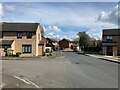
Hine Avenue in Newark
Eastern suburb of the town located in the Beacon Hill area. The junction with Hounsfield Close can be seen on the left.
Image: © Jonathan Clitheroe
Taken: 30 Mar 2024
0.15 miles
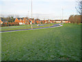
4
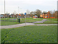
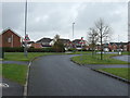
New housing on Newbury Road
Looking southwest to the roundabout and lots of new houses on this large estate.
Image: © Trevor Rickard
Taken: 10 Dec 2011
0.19 miles
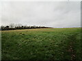
5
Land at the end of Blatherwick Road, Newark
Who can say whether houses will eventually be built here? It is a natural extension of Blatherwick Road development.
Image: © Julian P Guffogg
Taken: 3 Mar 2016
0.20 miles
7
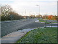
Beacon Hill Road
Looking west at the junction with Autumn Croft Road.
Image: © Trevor Rickard
Taken: 10 Dec 2011
0.22 miles
9
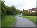
Newbury Road
Looking north along this curiously single track yet dual carriageway road.
Image: © Trevor Rickard
Taken: 10 Dec 2011
0.24 miles
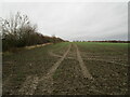
10
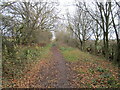
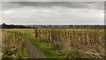
Clay Lane
At this point a bridleway.
Image: © Jonathan Thacker
Taken: 17 Nov 2020
0.24 miles