IMAGES TAKEN NEAR TO
Crankley Point, NEWARK, NG24 2EB
Introduction
This page details the photographs taken nearby to Crankley Point, NG24 2EB by members of the Geograph project.
The Geograph project started in 2005 with the aim of publishing, organising and preserving representative images for every square kilometre of Great Britain, Ireland and the Isle of Man.

There are currently over 7.5m images from over14,400 individuals and you can help contribute to the project by visiting https://www.geograph.org.uk
Image Map
Images are licensed for reuse under creativecommons.org/licenses/by-sa/2.0
Notes
- Clicking on the map will re-center to the selected point.
- The higher the marker number, the further away the image location is from the centre of the postcode.
Image Listing (78 Images Found)
Images are licensed for reuse under creativecommons.org/licenses/by-sa/2.0
Image
Details
Distance
1
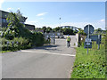
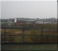
Entrance to sewage works
The man in the hi-vi had been opening the level crossing for a vehicle to pass.
Image: © Alan Murray-Rust
Taken: 4 Sep 2012
0.01 miles
2
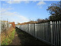
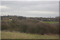
Footpath by the railway
The security fencing feels particularly oppressive.
Image: © Jonathan Thacker
Taken: 14 Dec 2020
0.02 miles
3
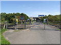
Crankley Point Crossing
Technically known as a UWC (User worked crossing), where users are responsible for checking that the line is clear before crossing. This is the access to Newark's sewage works.
Image: © Alan Murray-Rust
Taken: 4 Sep 2012
0.02 miles
4
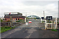
Level crossing in North Newark
The gates have to be opened and closed by the user, and lead into the sewage works. The railway bridge in the background takes the main line over the Winthorpe Rack (part of the River Trent)
Image: © Andy Stephenson
Taken: 16 Apr 2005
0.03 miles
6
Bushes by the East Coast Main Line
The bushes are obscuring (not to well) the Newark Sewage works.
Image: © N Chadwick
Taken: 25 Feb 2011
0.05 miles
7
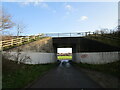
Quibell's Lane passing beneath the A46
Image: © Jonathan Thacker
Taken: 14 Dec 2020
0.06 miles
8
ECML Crosses River Trent
The East coast main line at Newark
Image: © David Hopewell
Taken: 6 Aug 2006
0.07 miles
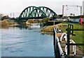
9
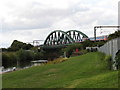
Newark Dyke Bridge
66191 hauls a Scunthorpe to Ebange (France) steel train.
Image: © Jonathan Thacker
Taken: 4 Jun 2011
0.08 miles
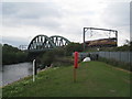
10
Newark Dyke Bridge
This is the third girder bridge to carry the East Coast Main Line across the Trent north of Newark. The original wrought- and cast-iron structure lasted from 1852-89 and its replacement until 2000, when this bridge - only two years old when the picture was taken - was slid into place over the August Bank Holiday.
In the olden days this was a good place for trainspotting, with exciting expresses on the ECML and more prosaic locals on the Nottingham-Lincoln line behind the camera - not to mention barges on the river to watch in between trains, stones to throw and sherbet lemons to suck. It seems amazing to me now that as 12-year-olds my friends and I used to cycle here for the day from Nottingham, via Oxton and Southwell.
Image: © John Sutton
Taken: Unknown
0.08 miles