IMAGES TAKEN NEAR TO
Wolsey Road, NEWARK, NG24 2BQ
Introduction
This page details the photographs taken nearby to Wolsey Road, NG24 2BQ by members of the Geograph project.
The Geograph project started in 2005 with the aim of publishing, organising and preserving representative images for every square kilometre of Great Britain, Ireland and the Isle of Man.

There are currently over 7.5m images from over14,400 individuals and you can help contribute to the project by visiting https://www.geograph.org.uk
Image Map
Images are licensed for reuse under creativecommons.org/licenses/by-sa/2.0
Notes
- Clicking on the map will re-center to the selected point.
- The higher the marker number, the further away the image location is from the centre of the postcode.
Image Listing (32 Images Found)
Images are licensed for reuse under creativecommons.org/licenses/by-sa/2.0
Image
Details
Distance
1
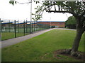
Bishop Alexander School
A school opened on this site in the years after the Second World War. This was replaced by the present building in 2009. It has many interesting features, see http://www.publicarchitecture.co.uk/knowledge-base/files/bishop_alexander_eco_school_project.pdf for more detail.
Image: © Jonathan Thacker
Taken: 4 Jun 2011
0.05 miles
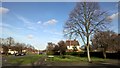
3
Pebbledash-coated #23 Alexander Avenue from side track
Image: © phil Richards
Taken: 3 Oct 2016
0.09 miles
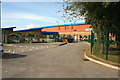
4
Junction of Winthorpe Road and Park Crescent, Newark
Image: © Chris Morgan
Taken: 1 Feb 2016
0.10 miles
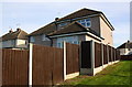
5
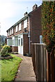
Houses at junction of Winthorpe Road and Stephen Road
There is an OS benchmark Image on the side of the near house, hidden by the wooden fence
Image: © Roger Templeman
Taken: 3 Oct 2016
0.10 miles
6
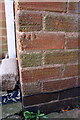
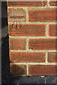
Benchmark on #1 Stephen Road
Ordnance Survey cut mark benchmark described on the Bench Mark Database at http://www.bench-marks.org.uk/bm79516
Image: © Roger Templeman
Taken: 3 Oct 2016
0.11 miles
7
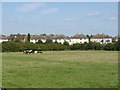
The back of Alexander Avenue
Part of the post-war Winthorpe Road housing estate. A group of travellers' horses are pastured in the field in the foreground.
Image: © Alan Murray-Rust
Taken: 4 Sep 2012
0.11 miles
8
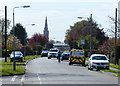
Winthorpe Road in Newark-on-Trent
In the distance is the spire of St Mary Magdalene church.
Image: © Mat Fascione
Taken: 19 Apr 2016
0.14 miles
9
Benchmark on #77 Winthorpe Road
Ordnance Survey cut mark benchmark described on the Bench Mark Database at http://www.bench-marks.org.uk/bm79515
Image: © Roger Templeman
Taken: 3 Oct 2016
0.15 miles
10
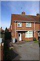
#77 Winthorpe Road
There is an OS benchmark Image on the front of the house, left hand corner, behind the wheelie bin
Image: © Roger Templeman
Taken: 3 Oct 2016
0.15 miles