IMAGES TAKEN NEAR TO
Quibells Lane, NEWARK, NG24 2AL
Introduction
This page details the photographs taken nearby to Quibells Lane, NG24 2AL by members of the Geograph project.
The Geograph project started in 2005 with the aim of publishing, organising and preserving representative images for every square kilometre of Great Britain, Ireland and the Isle of Man.

There are currently over 7.5m images from over14,400 individuals and you can help contribute to the project by visiting https://www.geograph.org.uk
Image Map
Images are licensed for reuse under creativecommons.org/licenses/by-sa/2.0
Notes
- Clicking on the map will re-center to the selected point.
- The higher the marker number, the further away the image location is from the centre of the postcode.
Image Listing (102 Images Found)
Images are licensed for reuse under creativecommons.org/licenses/by-sa/2.0
Image
Details
Distance
2
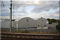
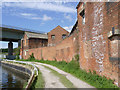
Deserted factory
The former Henkel adhesives factory on Quibell's Lane.
Image: © Alan Murray-Rust
Taken: 4 Sep 2012
0.03 miles
3
Former Chemical Manure factory
Precisely what Chemical Manure was is not clear, but this is the way it is labelled on old maps. The last remaining buildings are framed by the girders of Nether Lock Viaduct.
Image: © Alan Murray-Rust
Taken: 4 Sep 2012
0.04 miles
4
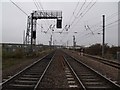
East Coast Main Line Railway, near Newark North Gate station
Looking north.
Image: © J.Hannan-Briggs
Taken: 5 Nov 2011
0.04 miles
5
Former Chemical Manure factory
Overlooking the River Trent towpath, which serves here as vehicle access to Nether Lock.
Image: © Alan Murray-Rust
Taken: 4 Sep 2012
0.04 miles
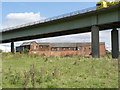
7
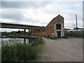
The remains of Quibells' factory
'Quibs' or 'the glue factory' could sometimes have a rather unpleasant effect on the atmosphere of its surroundings. Most of the factory has been demolished to make way for the A46 viaduct but this small section remains - derelict. The East Coast Main Line runs to the right and the River Trent completes the sides of this small triangle of land.
Image: © Jonathan Thacker
Taken: 4 Jun 2011
0.04 miles
8
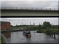
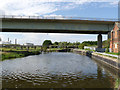
Beneath the viaduct
A narrowboat passes beneath the A46 viaduct on the Newark branch of the River Trent just upstream from Newark Nether Lock.
Image: © Jonathan Thacker
Taken: 4 Jun 2011
0.06 miles
9
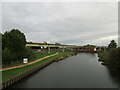
The approach to Nether Lock
Now dominated by the A46 viaduct. Also visible are the top of the weir, the Midland Railway viaduct and the sugar factory.
Image: © Alan Murray-Rust
Taken: 4 Sep 2012
0.06 miles
10
The River Trent (Newark Branch) and the A46 flyover
Image: © Jonathan Thacker
Taken: 26 Oct 2021
0.06 miles