IMAGES TAKEN NEAR TO
Hatchets Lane, NEWARK, NG24 2AD
Introduction
This page details the photographs taken nearby to Hatchets Lane, NG24 2AD by members of the Geograph project.
The Geograph project started in 2005 with the aim of publishing, organising and preserving representative images for every square kilometre of Great Britain, Ireland and the Isle of Man.

There are currently over 7.5m images from over14,400 individuals and you can help contribute to the project by visiting https://www.geograph.org.uk
Image Map
Images are licensed for reuse under creativecommons.org/licenses/by-sa/2.0
Notes
- Clicking on the map will re-center to the selected point.
- The higher the marker number, the further away the image location is from the centre of the postcode.
Image Listing (99 Images Found)
Images are licensed for reuse under creativecommons.org/licenses/by-sa/2.0
Image
Details
Distance
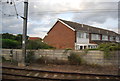
2
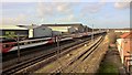
Newark-on-Trent - Hatchets Lane Crossing
An alternative view (and more recent) of this crossing of the East Coast Main Line from the west (Whitehouse Lane) side is provided at Image
Image: © Dave Bevis
Taken: 1 Jul 1989
0.07 miles
3
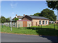
Winthorpe Road Baptist Church
A very unassuming building serving the post-war housing estates to the north of Newark.
Image: © Alan Murray-Rust
Taken: 4 Sep 2012
0.07 miles
4
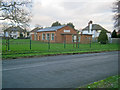
Baptist chapel on Winthorpe Road
Chapel on the north side of the road surrounded by a small green.
Image: © Trevor Rickard
Taken: 18 Dec 2011
0.07 miles
5
Virgin East Coast in the shade heading north
Stationary after passing Newark Northgate
Image: © Chris Morgan
Taken: 1 Feb 2016
0.07 miles
6

The Church of Promise
Formerly the Winthorpe Road Baptist Church
Image: © Graham Hogg
Taken: 29 Feb 2016
0.08 miles
7
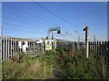
Permanently closed footpath
The footpath from Hatchets lane to the Trent bank is now permanently closed. At one time it provided vehicular access to various maltings and factories but with their demise it was reduced to a footpath. It was part of the Trent Valley Way but I have been unable to find which way this has been re-routed.
Image: © Jonathan Thacker
Taken: 24 Aug 2019
0.08 miles
8
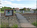
Light controlled pedestrian crossing - green
Hatchet's Lane crosses the East Coast Main Line; trains pass this point at speeds in excess of 100 mph. This http://www.geograph.org.uk/photo/3129956 gives the alternative view.
The path is part of the Trent Valley Way long distance footpath.
Image: © Alan Murray-Rust
Taken: 4 Sep 2012
0.08 miles
9
Light controlled pedestrian crossing - red
The alternative scenario to http://www.geograph.org.uk/photo/3129946 . Definitely not worth jumping the lights!
The locomotive is a class 66 diesel on heavy freight haulage and was accelerating away from a stop.
The path is part of the Trent Valley Way long distance footpath.
Image: © Alan Murray-Rust
Taken: 4 Sep 2012
0.08 miles
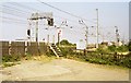
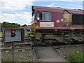
10
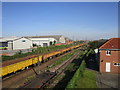
Ready for action
Newark Crossing (where the East Coast main line crosses the Nottingham to Lincoln line) is being replaced and no trains (except for engineering trains like this) will run over this August Bank Holiday weekend.
Image: © Jonathan Thacker
Taken: 24 Aug 2019
0.09 miles