IMAGES TAKEN NEAR TO
Old School Lane, NEWARK, NG24 1TD
Introduction
This page details the photographs taken nearby to Old School Lane, NG24 1TD by members of the Geograph project.
The Geograph project started in 2005 with the aim of publishing, organising and preserving representative images for every square kilometre of Great Britain, Ireland and the Isle of Man.

There are currently over 7.5m images from over14,400 individuals and you can help contribute to the project by visiting https://www.geograph.org.uk
Image Map
Images are licensed for reuse under creativecommons.org/licenses/by-sa/2.0
Notes
- Clicking on the map will re-center to the selected point.
- The higher the marker number, the further away the image location is from the centre of the postcode.
Image Listing (66 Images Found)
Images are licensed for reuse under creativecommons.org/licenses/by-sa/2.0
Image
Details
Distance
1
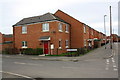
New housing at junction of Old School Lane and Cromwell Road
On the site of the former Barnby Road Infants School
Image: © phil Richards
Taken: 1 May 2016
0.02 miles
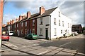
3
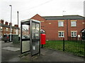
Working phone box. Barnby Road, Newark
Image: © Jonathan Thacker
Taken: 14 Jan 2023
0.04 miles
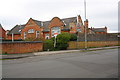
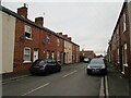
4
Cromwell Road
Terraced houses in Newark
Image: © Richard Croft
Taken: 16 Oct 2008
0.05 miles
5
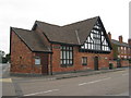
The former St. Augustine's Mission Church
Image: © Jonathan Thacker
Taken: 6 Aug 2010
0.05 miles
6
Wright Street, Newark
The scene of my first failed driving test.
Image: © Jonathan Thacker
Taken: 17 Nov 2020
0.06 miles
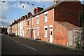
7
Wright Street
View down Wright Street from Cromwell Road
Image: © Richard Croft
Taken: 16 Oct 2008
0.06 miles
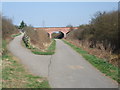
10
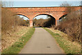
Clay Lane Bridge
Bridge over route 64 in Newark
Image: © Richard Croft
Taken: 25 Mar 2012
0.06 miles