IMAGES TAKEN NEAR TO
William Street, NEWARK, NG24 1QS
Introduction
This page details the photographs taken nearby to William Street, NG24 1QS by members of the Geograph project.
The Geograph project started in 2005 with the aim of publishing, organising and preserving representative images for every square kilometre of Great Britain, Ireland and the Isle of Man.

There are currently over 7.5m images from over14,400 individuals and you can help contribute to the project by visiting https://www.geograph.org.uk
Image Map
Images are licensed for reuse under creativecommons.org/licenses/by-sa/2.0
Notes
- Clicking on the map will re-center to the selected point.
- The higher the marker number, the further away the image location is from the centre of the postcode.
Image Listing (166 Images Found)
Images are licensed for reuse under creativecommons.org/licenses/by-sa/2.0
Image
Details
Distance
1
The New Inn, Barnby Gate
Not so new, and not so Inn. Late 19th century. Note the uncovered 'Courage' name between the first floor windows. Courage were a Reading-based firm who took over the John Smith's, Newark Brewery (formerly Hope's).
Image: © Alan Murray-Rust
Taken: 31 Aug 2012
0.03 miles
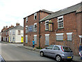
2
The former New Inn, William Street, Newark
Now in residential use.
Image: © Jonathan Thacker
Taken: 14 Jan 2023
0.03 miles
3
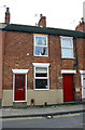
#114 Barnby Gate
Cement render applied to bottom 3ft. of the front of the house
Image: © phil Richards
Taken: 1 May 2016
0.03 miles
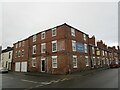
5
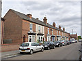
75 to 93 Barnby Gate
A traditional, uniform, row of late Victorian terraced houses, with bay windows.
Image: © Alan Murray-Rust
Taken: 31 Aug 2012
0.04 miles
6
Cut Mark 26 Whitfield Rd Newark on Trent
Image: © Monica Stagg
Taken: 7 Sep 2015
0.04 miles
7

Barnby Gate, Newark on Trent
Looking towards the town centre at the junction with Cross Street.
Image: © Stephen McKay
Taken: 13 Nov 2006
0.05 miles
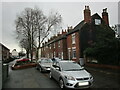
8
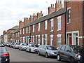
Terraced houses, Barnby Gate
On large scale maps, it's clear that the houses are not quite as uniform as the frontages would suggest.
Image: © Alan Murray-Rust
Taken: 31 Aug 2012
0.05 miles
9
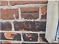
Benchmark on #26 Whitfield Street
Ordnance Survey cut mark benchmark described on the Bench Mark Database at http://www.bench-marks.org.uk/bm70257
Image: © Roger Templeman
Taken: 1 May 2016
0.05 miles
10

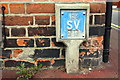
#26 Whitfield Street at New Street junction
There is an OS benchmark Image on the near corner, left hand face, of the house left of the SV post
Image: © Roger Templeman
Taken: 1 May 2016
0.05 miles