IMAGES TAKEN NEAR TO
St. Georges Court, NEWARK, NG24 1NW
Introduction
This page details the photographs taken nearby to St. Georges Court, NG24 1NW by members of the Geograph project.
The Geograph project started in 2005 with the aim of publishing, organising and preserving representative images for every square kilometre of Great Britain, Ireland and the Isle of Man.

There are currently over 7.5m images from over14,400 individuals and you can help contribute to the project by visiting https://www.geograph.org.uk
Image Map
Images are licensed for reuse under creativecommons.org/licenses/by-sa/2.0
Notes
- Clicking on the map will re-center to the selected point.
- The higher the marker number, the further away the image location is from the centre of the postcode.
Image Listing (284 Images Found)
Images are licensed for reuse under creativecommons.org/licenses/by-sa/2.0
Image
Details
Distance
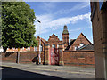
1
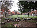
Play area, Lovers Lane Primary School
In the background one of Newark's many former maltkilns.
Image: © Jonathan Thacker
Taken: 1 Jan 2019
0.01 miles
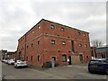
2
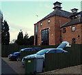
George Street Maltings, North End, Newark, Notts.
Former maltings that seem likely to have been part of the former Warwick's and Richardson's Northgate Brewery where brewing began in 1872. The brewery buildings can still be seen 300-400 metres away to the left on the other side of the B6166 (i.e. Northgate). These maltings are now housing units.
Image: © David Hallam-Jones
Taken: 1 Feb 2015
0.02 miles
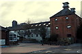
3
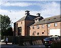
Former maltings, George Street
A reminder of the extensive brewing industry in the town, now converted to residential properties.
Image: © Alan Murray-Rust
Taken: 4 Sep 2012
0.02 miles
4
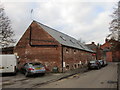
Former maltings, George Street
Now converted to housing.
For a description of this and other maltings in Newark see http://www.newarkcivictrust.org.uk/downloads/MaltingBrewingTrail.pdf
For a description of the malting process see https://en.wikipedia.org/wiki/Malt_house
Image: © Jonathan Thacker
Taken: 1 Jan 2019
0.02 miles
5
Former maltings, George Street
Now converted to housing.
For a description of this and other maltings in Newark see http://www.newarkcivictrust.org.uk/downloads/MaltingBrewingTrail.pdf
For a description of the malting process see https://en.wikipedia.org/wiki/Malt_house
Image: © Jonathan Thacker
Taken: 1 Jan 2019
0.02 miles
6
George Street Maltings, North End, Newark, Notts.
These former maltings in George Street are visible from the playground of Lover's Lane Primary School. These seem likely to have been part of the former Warwick's and Richardson's Northgate Brewery, on the other side of the B6166, (i.e. Northgate, 200-300 metres away to the right). They have been converted into flats.
Image: © David Hallam-Jones
Taken: 1 Feb 2015
0.03 miles
7
Plaque to George William "Willie" Hall
England & Tottenham Hotspur forward who scored the then fastest hat-trick in international football.
Image: © El Loco
Taken: 23 May 2021
0.03 miles
8
Lovers Lane Primary School, Newark
Shows position of plaque to footballer "Willie" Hall Image to right of window central in photo.
Image: © El Loco
Taken: 23 May 2021
0.03 miles
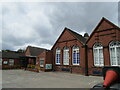
9
Lovers Lane Primary School
Typical late 19th century school in quite ornate brickwork.
Image: © Alan Murray-Rust
Taken: 4 Sep 2012
0.03 miles
10
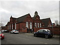
Lovers Lane Primary School
Seen from Warburton Street.
Dates from 1895 and was designed by Hine and Son of Nottingham.
Image: © Jonathan Thacker
Taken: 1 Jan 2019
0.03 miles