IMAGES TAKEN NEAR TO
Lawrence Place, NEWARK, NG24 1NA
Introduction
This page details the photographs taken nearby to Lawrence Place, NG24 1NA by members of the Geograph project.
The Geograph project started in 2005 with the aim of publishing, organising and preserving representative images for every square kilometre of Great Britain, Ireland and the Isle of Man.

There are currently over 7.5m images from over14,400 individuals and you can help contribute to the project by visiting https://www.geograph.org.uk
Image Map
Images are licensed for reuse under creativecommons.org/licenses/by-sa/2.0
Notes
- Clicking on the map will re-center to the selected point.
- The higher the marker number, the further away the image location is from the centre of the postcode.
Image Listing (191 Images Found)
Images are licensed for reuse under creativecommons.org/licenses/by-sa/2.0
Image
Details
Distance
1
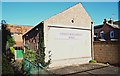
Cliff Nook Lane, Newark on Trent, Notts.
This Christadelphian Hall has been added onto a small cottage. Apparently there has been a Christadelphian ecclesia in Newark since 1850. A noticeboard near the entrance informs passers-by that several services are held here each Sunday.
Image: © David Hallam-Jones
Taken: 5 Nov 2017
0.05 miles
2
Cliff Nook Lane, Newark on Trent, Notts.
This Christadelphian Hall has been added onto a small cottage. Apparently there has been a Christadelphian ecclesia in Newark since 1850. A noticeboard near the entrance informs passers-by that several services are held here each Sunday.
Image: © David Hallam-Jones
Taken: 5 Nov 2017
0.06 miles
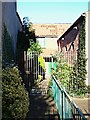
3
Northern Terrace
Northern Terrace, dating from 1881 on Appleton Gate, Newark on Trent
Image: © Andrew Abbott
Taken: 17 Feb 2020
0.07 miles
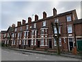
5
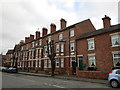
Terraced houses, Appletongate, Newark on Trent
Three storey terraces of this age are unusual in Newark.
Image: © Jonathan Thacker
Taken: 1 Jan 2019
0.07 miles
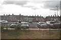
6
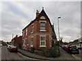
The junction of Sydney Street and Appleton Gate
Sydney Street is on the left.
Image: © Jonathan Thacker
Taken: 1 Jan 2019
0.08 miles
7
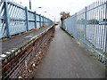
Platform edge, former railway line, Newark Northgate
This disused freight line on the west side of the station now forms part of cycle route 64, part of the National Byway.
Image: © Christine Johnstone
Taken: 18 Jan 2014
0.08 miles
8
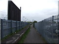
Cycle Route 64 heading south near Newark Northgate Station
Image: © JThomas
Taken: 3 May 2012
0.08 miles
9
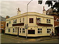
The Newcastle Arms, George Street, Newark on Trent
Image: © Andrew Abbott
Taken: 28 Jul 2010
0.09 miles
10
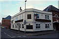
Newcastle Arms, George Street, North End, Newark, Notts.
Former maltings buildings on either side of The Newcastle Arms public house from Appleton Gate. The maltings, that have now been converted for housing and commercial purposes seem likely to have been part of the former Warwick's and Richardson's Northgate Brewery, where brewing began in 1872. The brewery buildings can still be seen 500 metres (ahead, as the crow flies) on the other side of the B6166 (i.e. Northgate).
Image: © David Hallam-Jones
Taken: 1 Feb 2015
0.09 miles