IMAGES TAKEN NEAR TO
Tithe Barn Court, NEWARK, NG24 1JA
Introduction
This page details the photographs taken nearby to Tithe Barn Court, NG24 1JA by members of the Geograph project.
The Geograph project started in 2005 with the aim of publishing, organising and preserving representative images for every square kilometre of Great Britain, Ireland and the Isle of Man.

There are currently over 7.5m images from over14,400 individuals and you can help contribute to the project by visiting https://www.geograph.org.uk
Image Map
Images are licensed for reuse under creativecommons.org/licenses/by-sa/2.0
Notes
- Clicking on the map will re-center to the selected point.
- The higher the marker number, the further away the image location is from the centre of the postcode.
Image Listing (418 Images Found)
Images are licensed for reuse under creativecommons.org/licenses/by-sa/2.0
Image
Details
Distance
1
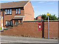
Lovers Lane postbox (ref. NG24 7)
GVIR wall box in what appears to be a rebuilt wall. Old maps show that there was a box at this location before the reign of George VI, so it is clearly a replacement.
Image: © Alan Murray-Rust
Taken: 4 Sep 2012
0.03 miles
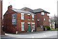
2
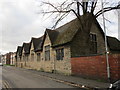
Former school
Attached to the now demolished St. Leonard's church.
Image: © Jonathan Thacker
Taken: 1 Jan 2019
0.04 miles
3
Scout Hall, Lovers Lane
This was originally a school attached to the former St Leonard's Church (now demolished) on Northgate.
Image: © Alan Murray-Rust
Taken: 4 Sep 2012
0.04 miles
4
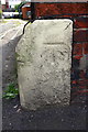
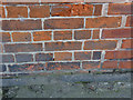
Benchmark on #78 North Gate
Ordnance Survey cur mark benchmark described on the Bench Mark Database at http://www.bench-marks.org.uk/bm22336
Image: © Roger Templeman
Taken: 1 May 2016
0.04 miles
5
#78 North Gate
There is an OS benchmark Image on the white guardstone on the near corner of the house
Image: © Roger Templeman
Taken: 1 May 2016
0.04 miles
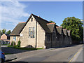
6
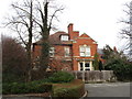
The former St. Leonard's Vicarage
A new St. Leonard's church and vicarage were built on Lincoln Road in the 1970s.
Image: © Jonathan Thacker
Taken: 19 Feb 2019
0.06 miles
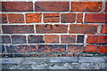
9
Bench mark, 17 King's Road
Cut mark in brickwork. The bench mark is actually on the Queen's Road face of the building http://www.geograph.org.uk/photo/3113135.
Image: © Alan Murray-Rust
Taken: 31 Aug 2012
0.07 miles
10
Benchmark on #17 King's Road (Queen's Road face)
Ordnance Survey cut mark benchmark described on the Bench Mark Database at http://www.bench-marks.org.uk/bm45341
Image: © Roger Templeman
Taken: 1 May 2016
0.07 miles