IMAGES TAKEN NEAR TO
Lovers Lane, NEWARK, NG24 1HU
Introduction
This page details the photographs taken nearby to Lovers Lane, NG24 1HU by members of the Geograph project.
The Geograph project started in 2005 with the aim of publishing, organising and preserving representative images for every square kilometre of Great Britain, Ireland and the Isle of Man.

There are currently over 7.5m images from over14,400 individuals and you can help contribute to the project by visiting https://www.geograph.org.uk
Image Map
Images are licensed for reuse under creativecommons.org/licenses/by-sa/2.0
Notes
- Clicking on the map will re-center to the selected point.
- The higher the marker number, the further away the image location is from the centre of the postcode.
Image Listing (237 Images Found)
Images are licensed for reuse under creativecommons.org/licenses/by-sa/2.0
Image
Details
Distance
1
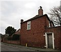
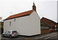
Rose Cottage, Lovers Lane
Built at a slight angle to the street.
Image: © Jonathan Thacker
Taken: 1 Jan 2019
0.01 miles
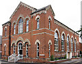
3
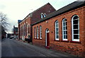
![North End Wesleyan Chapel [former]](https://s0.geograph.org.uk/geophotos/06/52/53/6525360_5112c933_120x120.jpg)
North End Wesleyan Chapel [former]
Completed in about 1870, the chapel could accommodate some 700 worshippers. It has now been converted into apartments but services continue in the adjacent schoolroom which was previously associated with the chapel and is of a similar age.
Image: © John Lucas
Taken: 22 Jan 2020
0.05 miles
4
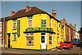
Tasty Bites
Donna B's Tasty Bites takeaway food business on the corner of Northgate and Currie Road ..... not easily missed !
Image: © Richard Croft
Taken: 24 Jul 2012
0.05 miles
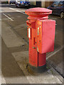
5
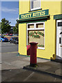
Northgate Post Office postbox (ref. NG24 15)
EIIR (Post Office) pillar box. The Post Office has now become a snacks outlet. On the corner of Currie Road, it will of course do you Chilli and Rice!
Image: © Alan Murray-Rust
Taken: 4 Sep 2012
0.05 miles
6
Northgate Post Office postbox (ref. NG24 15)
EIIR (Post Office) pillar box. The attached stamp vending machine (no longer selling stamps) is a real rarity.
Image: © Alan Murray-Rust
Taken: 4 Sep 2012
0.05 miles
7
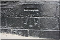
Benchmark on #160 North Gate
Ordnance Survey cut mark benchmark described on the Bench Mark Database at http://www.bench-marks.org.uk/bm75278
Image: © Roger Templeman
Taken: 1 May 2016
0.05 miles
8
#160 North Gate, 'Fosse Cottage', at Summer's Road junction
There is an OS benchmark Image on the black bricks at the near corner, left hand face, of the house
Image: © Roger Templeman
Taken: 1 May 2016
0.05 miles
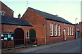
9
North End Methodist Church, Lover's Lane, Newark, Notts.
The former North End Methodist Church was situated within the largest building in the picture. The original congregation began to meet there from 1868 as a 'church plant' from Newark's principal Methodist Church, Barnby Gate Church. The congregation now worships within one of its ancillary buildings that has now been adapted for this purpose and the original church has been converted in flats. The church still owns two buildings on this site, i.e. the one nearest to the camera and another behind these two. The second building can also be accessed from Meyrick Road (first turning on the right).
Image: © David Hallam-Jones
Taken: 1 Feb 2015
0.05 miles
10
Methodist Church, Lover's Lane, Newark, Notts.
North End Methodist Church, Lover's Lane. The original, and much larger, church building - around the corner in Meyrick Road - was established in 1868 as an offshoot of Newark's principal Methodist Church, Barnby Gate Church. However, the congregation now worships in one of its ancillary buildings that has been adapted for this purpose, i.e. either in this rectangular building or in another building that the church also owns that can be accessed from Meyrick Road. The original church has been converted in flats.
Image: © David Hallam-Jones
Taken: 1 Feb 2015
0.06 miles