IMAGES TAKEN NEAR TO
Alliance Street, NEWARK, NG24 1HR
Introduction
This page details the photographs taken nearby to Alliance Street, NG24 1HR by members of the Geograph project.
The Geograph project started in 2005 with the aim of publishing, organising and preserving representative images for every square kilometre of Great Britain, Ireland and the Isle of Man.

There are currently over 7.5m images from over14,400 individuals and you can help contribute to the project by visiting https://www.geograph.org.uk
Image Map
Images are licensed for reuse under creativecommons.org/licenses/by-sa/2.0
Notes
- Clicking on the map will re-center to the selected point.
- The higher the marker number, the further away the image location is from the centre of the postcode.
Image Listing (219 Images Found)
Images are licensed for reuse under creativecommons.org/licenses/by-sa/2.0
Image
Details
Distance
3
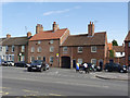
Blue Man Court
The name comes from the fact that the main building was formerly The Blue Man public house. The main building has been recently restored with its concrete tiles replaced with traditional pantiles, paintwork removed from the facade and more traditional Yorkshire-casement style windows. It dates from the early 19th century and inclusive of the cottages to its right is Listed Grade II.
Image: © Alan Murray-Rust
Taken: 4 Sep 2012
0.04 miles
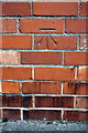
7
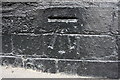
Benchmark on #160 North Gate
Ordnance Survey cut mark benchmark described on the Bench Mark Database at http://www.bench-marks.org.uk/bm75278
Image: © Roger Templeman
Taken: 1 May 2016
0.05 miles
8
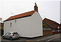
#160 North Gate, 'Fosse Cottage', at Summer's Road junction
There is an OS benchmark Image on the black bricks at the near corner, left hand face, of the house
Image: © Roger Templeman
Taken: 1 May 2016
0.05 miles
9
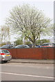
Wall of car park, Lincoln Street
There is an OS benchmark Image on the wall midway between the two piers
Image: © Roger Templeman
Taken: 1 May 2016
0.06 miles
10
Benchmark on wall of Lincoln Street
Ordnance Survey cut mark benchmark described on the Bench Mark Database at http://www.bench-marks.org.uk/bm75279
Image: © Roger Templeman
Taken: 1 May 2016
0.06 miles