IMAGES TAKEN NEAR TO
Water Lane, NEWARK, NG24 1HA
Introduction
This page details the photographs taken nearby to Water Lane, NG24 1HA by members of the Geograph project.
The Geograph project started in 2005 with the aim of publishing, organising and preserving representative images for every square kilometre of Great Britain, Ireland and the Isle of Man.

There are currently over 7.5m images from over14,400 individuals and you can help contribute to the project by visiting https://www.geograph.org.uk
Image Map
Images are licensed for reuse under creativecommons.org/licenses/by-sa/2.0
Notes
- Clicking on the map will re-center to the selected point.
- The higher the marker number, the further away the image location is from the centre of the postcode.
Image Listing (937 Images Found)
Images are licensed for reuse under creativecommons.org/licenses/by-sa/2.0
Image
Details
Distance
1
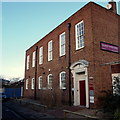
Water Lane, Off Northgate, Newark, Notts.
This former telephone exchange and works yard dates from 1938. It now houses a cluster of business offices. The B6166 (Northgate) lies a dozen paces away on the right, whereas to the left, a footpath links the closed end of this cul-de-sac to a path that runs parallel with the River Trent.
Image: © David Hallam-Jones
Taken: 1 Feb 2015
0.01 miles
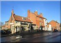
2
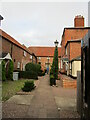
Courtyard off Northgate, Newark
Largely eighteenth and early nineteenth century buildings. The house on the right is 35 Northgate https://historicengland.org.uk/listing/the-list/list-entry/1231619
Image: © Jonathan Thacker
Taken: 26 Oct 2021
0.02 miles
3
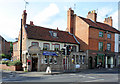
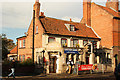
The Malt Shovel, Northgate
18th century brick built pub with a slightly incongruous early 20th century extension of terracotta/faience. The houses to the right also date back to the mid 18th century, with 19th century extensions, with traditional shopfronts. The pub and the group of houses are listed Grade II.
Image: © Alan Murray-Rust
Taken: 15 Jul 2012
0.02 miles
4
27 to 31 Northgate, Newark
Mid eighteenth century houses with later top floor https://historicengland.org.uk/listing/the-list/list-entry/1277463
Image: © Jonathan Thacker
Taken: 26 Oct 2021
0.03 miles
5
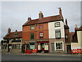
The Old Malt Shovel
Grade II listed, mid 18th century public house with a single-storey front of c1900. A traditional pub with seriously good beer.
Image: © Richard Croft
Taken: 5 Nov 2012
0.03 miles
6
The Old Malt Shovel and adjacent buildings
The name of the Old Malt Shovel is indicative of a once major activity in this area. The building dates from the mid eighteenth century though the single storey front is of about 1900 https://historicengland.org.uk/listing/the-list/list-entry/1196411 . The adjacent buildings are of similar date https://historicengland.org.uk/listing/the-list/list-entry/1277463
Image: © Jonathan Thacker
Taken: 22 Jan 2021
0.03 miles
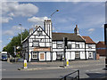
7
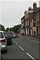
Northgate/Queens Road Junction, Newark, Notts.
The White Swan on this corner site. The town centre lies to the right; to the left the B6166 leads towards the A46 and the A1 and finally, Queens Road leads to the A1 via Sleaford Road and Beacon Hill Road.
Image: © David Hallam-Jones
Taken: 1 Feb 2015
0.04 miles
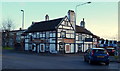
9
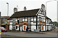
The White Swan
Mock-timbered hostelry on the corner of Northgate and Queens Road in Newark
Image: © Richard Croft
Taken: 19 May 2012
0.04 miles
10
The White Swan, Northgate
The black and white effect is done entirely with render. Note the decorative panels at the top of the chimney stack.
Image: © Alan Murray-Rust
Taken: 31 Aug 2012
0.04 miles