IMAGES TAKEN NEAR TO
Sandhills Close, NEWARK, NG24 1FH
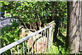
Introduction
This page details the photographs taken nearby to Sandhills Close, NG24 1FH by members of the Geograph project.
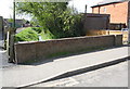
The Geograph project started in 2005 with the aim of publishing, organising and preserving representative images for every square kilometre of Great Britain, Ireland and the Isle of Man.

There are currently over 7.5m images from over14,400 individuals and you can help contribute to the project by visiting https://www.geograph.org.uk
Image Map
Images are licensed for reuse under creativecommons.org/licenses/by-sa/2.0
Notes
- Clicking on the map will re-center to the selected point.
- The higher the marker number, the further away the image location is from the centre of the postcode.
Image Listing (97 Images Found)
Images are licensed for reuse under creativecommons.org/licenses/by-sa/2.0
Image
Details
Distance
1
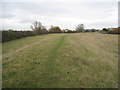
Flood bank at Newark
This protects the Kelham Road part of town which at one time was notorious for flooding.
Image: © Jonathan Thacker
Taken: 18 Nov 2011
0.03 miles
2
Trent Valley Way entering Newark via Kelham Road
Image: © Tim Heaton
Taken: 30 Dec 2008
0.09 miles
3
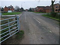
Kelham Road, Newark, Notts.
Presumably on match days these gates are opened to allow players and spectators who arrive by car to travel the final 100 metres before they enter the cricket club's car park? Walkers can however, at any time, continue on - through the side gate - in order to join a permissive footpath that soon joins the Trent Valley Path (a Long Distance Path). Behind the photographer however, lies a 0.5 km stretch of (residential) road that joins the Great North Road, i.e. the Newark to Kelham road. This seems likely to have been a link road between Newark and the village of Kelham but the new A46 has bisected this former connection.
Image: © David Hallam-Jones
Taken: 16 Jan 2016
0.09 miles
4
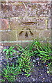
Benchmark on Kelham Road bridge
Ordnance Survey cut mark benchmark described on the Bench Mark Database at http://www.bench-marks.org.uk/bm75277
Image: © Roger Templeman
Taken: 1 May 2016
0.11 miles
5
South parapet of bridge on Kelham Road
There is an OS benchmark Image on the parapet about 2ft. right of the left hand pier
Image: © Roger Templeman
Taken: 1 May 2016
0.11 miles
6
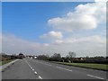
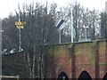
The A46 at Newark
The Trent Valley Way crosses this busy road here
Image: © Graham Hogg
Taken: 2 Nov 2015
0.12 miles
7
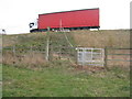
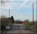
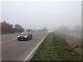
Crossing the A46
The Trent Valley Way crosses the A46 which at this point is on an embankment. The lorry in this picture is parked in a lay-by across the line of the footpath. So to cross at this point you have to poke your head out behind a lorry and then make some sort of judgement about whether or not you are prepared to risk your life crossing the road. Traffic is heavy and fast moving and given the speed of the traffic visibility is limited. If long distance paths are to be promoted then this sort of situation should be avoided. Because the road is on an embankment it should be possible to provide a pedestrian underpass here. I guess cost is the inhibiting factor.
Image: © Jonathan Thacker
Taken: 18 Nov 2011
0.15 miles
8
Layby near Newark on the A46 trunk road
Image: © Steve Fareham
Taken: 21 Mar 2012
0.15 miles
9
Small bridge beside Great North Road
There is an OS benchmark Image on a coping stone of the bridge parapet
Image: © Roger Templeman
Taken: 1 May 2016
0.15 miles
10
Old Road Bridge, Newark on Trent
Road bridge above waterlogged grounds at junction of A616 Great North Road, and A46, south of British Sugar works, near Newark on Trent.
Image: © Michael Westley
Taken: 24 Jan 2010
0.15 miles