IMAGES TAKEN NEAR TO
Kings Road, NEWARK, NG24 1EW
Introduction
This page details the photographs taken nearby to Kings Road, NG24 1EW by members of the Geograph project.
The Geograph project started in 2005 with the aim of publishing, organising and preserving representative images for every square kilometre of Great Britain, Ireland and the Isle of Man.

There are currently over 7.5m images from over14,400 individuals and you can help contribute to the project by visiting https://www.geograph.org.uk
Image Map
Images are licensed for reuse under creativecommons.org/licenses/by-sa/2.0
Notes
- Clicking on the map will re-center to the selected point.
- The higher the marker number, the further away the image location is from the centre of the postcode.
Image Listing (1066 Images Found)
Images are licensed for reuse under creativecommons.org/licenses/by-sa/2.0
Image
Details
Distance
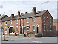
1
King's Road houses at Queen's Road junction
There is an OS benchmark Image on the near house under the Queen's Road road name sign
Image: © Roger Templeman
Taken: 1 May 2016
0.02 miles
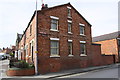
2
Houses on Kings Road
The return gable has an unusually high number of window openings, where often a completely blank wall appears.
Image: © Alan Murray-Rust
Taken: 31 Aug 2012
0.02 miles
4
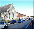
King's Road, Newark on Trent, Notts.
Although the former King's Road Unitarian Chapel was officially opened in 1884 eventually it was adapted for commercial purposes. The premises were last occupied by the Staythorpe Electricity Sports and Social Club. The club opened here in May 1954 with a 25-year lease after Staythorpe A Power Station began generating electricity for the National Grid in 1950. Staythorpe B Power Station was built later and began production in 1960. The employers were granted a further 20-year lease on the club’s premises in 1979. In 1994 these two power stations were shut down to allow for a new, replacement gas-fired power station to be built on the Staythorpe site, after which production restarted in December 2010. However, once the United Kingdom’s electricity generating industry was privatised this subsidised club became a working men’s club with the responsibility for covering its own costs. Although a further 20-year lease on the premises was granted in 1999, it seems that the club was affected by England’s 2007 tobacco smoking ban within licensed premises and also by competition from low priced alcohol being sold in supermarkets. As a result the decision was taken to close the club in April 2016 leaving the Unitarian Church’s owners to seek new tenants.
Image: © David Hallam-Jones
Taken: 29 Oct 2017
0.03 miles
5
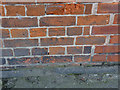
Bench mark, 17 King's Road
Cut mark in brickwork. The bench mark is actually on the Queen's Road face of the building http://www.geograph.org.uk/photo/3113135.
Image: © Alan Murray-Rust
Taken: 31 Aug 2012
0.03 miles
6
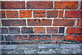
Benchmark on #17 King's Road (Queen's Road face)
Ordnance Survey cut mark benchmark described on the Bench Mark Database at http://www.bench-marks.org.uk/bm45341
Image: © Roger Templeman
Taken: 1 May 2016
0.03 miles
7
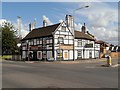
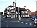
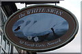
The White Swan
The impressive White Swan public house at the junction of North Gate and Queen's Road dates from 1794 and is still in use as a pub/restaurant today.
Image: © David Dixon
Taken: 8 Sep 2013
0.06 miles