IMAGES TAKEN NEAR TO
Sandhills Park, NEWARK, NG24 1DG
Introduction
This page details the photographs taken nearby to Sandhills Park, NG24 1DG by members of the Geograph project.
The Geograph project started in 2005 with the aim of publishing, organising and preserving representative images for every square kilometre of Great Britain, Ireland and the Isle of Man.

There are currently over 7.5m images from over14,400 individuals and you can help contribute to the project by visiting https://www.geograph.org.uk
Image Map
Images are licensed for reuse under creativecommons.org/licenses/by-sa/2.0
Notes
- Clicking on the map will re-center to the selected point.
- The higher the marker number, the further away the image location is from the centre of the postcode.
Image Listing (113 Images Found)
Images are licensed for reuse under creativecommons.org/licenses/by-sa/2.0
Image
Details
Distance
1
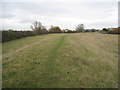
Flood bank at Newark
This protects the Kelham Road part of town which at one time was notorious for flooding.
Image: © Jonathan Thacker
Taken: 18 Nov 2011
0.06 miles
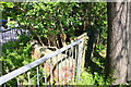
2
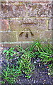
Benchmark on Kelham Road bridge
Ordnance Survey cut mark benchmark described on the Bench Mark Database at http://www.bench-marks.org.uk/bm75277
Image: © Roger Templeman
Taken: 1 May 2016
0.09 miles
3
South parapet of bridge on Kelham Road
There is an OS benchmark Image on the parapet about 2ft. right of the left hand pier
Image: © Roger Templeman
Taken: 1 May 2016
0.09 miles
4
Trent Valley Way entering Newark via Kelham Road
Image: © Tim Heaton
Taken: 30 Dec 2008
0.11 miles
5
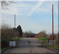
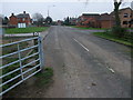
Kelham Road, Newark, Notts.
Presumably on match days these gates are opened to allow players and spectators who arrive by car to travel the final 100 metres before they enter the cricket club's car park? Walkers can however, at any time, continue on - through the side gate - in order to join a permissive footpath that soon joins the Trent Valley Path (a Long Distance Path). Behind the photographer however, lies a 0.5 km stretch of (residential) road that joins the Great North Road, i.e. the Newark to Kelham road. This seems likely to have been a link road between Newark and the village of Kelham but the new A46 has bisected this former connection.
Image: © David Hallam-Jones
Taken: 16 Jan 2016
0.11 miles
6
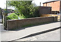
Small bridge beside Great North Road
There is an OS benchmark Image on a coping stone of the bridge parapet
Image: © Roger Templeman
Taken: 1 May 2016
0.12 miles
7
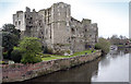
Newark Castle
Taken from the bridge, looking SW.
The majority of the castle we know today was built by Alexander the Magnificent, the Bishop of Lincoln and the Lord of the Manor of Newark in the early part of the 12th Century.
Image: © Andy Stephenson
Taken: 16 Apr 2005
0.12 miles
8
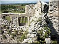
Within the ruins of Newark Castle
This picture was taken on a guided tour of the castle and shows a view of the Trent Valley beyond the market on Riverside Park.
Image: © Joan Priestley
Taken: 15 Sep 2004
0.12 miles
9
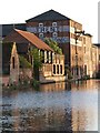
Down from the barge
View of buildings from other side of the Trent.
Image: © Team Dawson
Taken: 4 May 2005
0.12 miles
10
Benchmark on bridge parapet, Great North Road
Ordnance Survey rivet benchmark described on the Bench Mark Database at http://www.bench-marks.org.uk/bm75206
Image: © Roger Templeman
Taken: 1 May 2016
0.12 miles