IMAGES TAKEN NEAR TO
Loveridge Mews, NEWARK, NG24 1BJ
Introduction
This page details the photographs taken nearby to Loveridge Mews, NG24 1BJ by members of the Geograph project.
The Geograph project started in 2005 with the aim of publishing, organising and preserving representative images for every square kilometre of Great Britain, Ireland and the Isle of Man.

There are currently over 7.5m images from over14,400 individuals and you can help contribute to the project by visiting https://www.geograph.org.uk
Image Map
Images are licensed for reuse under creativecommons.org/licenses/by-sa/2.0
Notes
- Clicking on the map will re-center to the selected point.
- The higher the marker number, the further away the image location is from the centre of the postcode.
Image Listing (1451 Images Found)
Images are licensed for reuse under creativecommons.org/licenses/by-sa/2.0
Image
Details
Distance
1
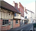
The Prince Rupert, Newark
The Good Beer Guide-listed pub is in a building dating from the 1400s.
Image: © Bill Boaden
Taken: 26 May 2014
0.02 miles
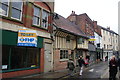
2
The Prince Rupert
Formerly The Woolpack on Stodman Street, a dramatic and fantastic transformation of a late 15th century Wealden House (minus the left-hand bays) to the popular and excellent Prince Rupert http://www.kneadpubs.co.uk/the-prince-rupert
Image: © Richard Croft
Taken: 19 May 2012
0.02 miles
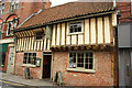
3
The Prince Rupert, 46 Stodman Street, Newark
Grade II Listed and half of a former Wealdon house of wood felled in spring 1452 and altered early 19th and late 20th century. The oldest and most northern example of a Wealden House it was possibly home to a wool merchant from Kent before becoming an inn as this would account for the Kentish design. It provided accommodation and stabling for Prince Rupert’s troops during the English Civil War according to 'Historic Coaching Inns of the Great North Road'. The left hand bay was removed at some point after the siege as it was probably damaged or burnt beyond repair. Formerly The Woolpack it was owned by the John Smith brewery, of Tadcaster who sold it in late 2007 or early 2008. Restoration started in mid 2009 with the re-opening as The Prince Rupert in 2010. Listed landlords of the Woolpack include; 1783 Inns and Beerhouses don't seem to be listed; 1791 John Ware; 1828-1841 Thomas Nevett; 1855 Thomas Fletcher; 1876 Ebenezer Paling; 1891 Simon Gaunt Wilford; 1892 Samuel C Willford; 1885 Edward Jackson (& coal merchant); 1904 George Fletcher.
Image: © Jo and Steve Turner
Taken: 6 Aug 2016
0.02 miles
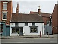
4
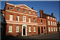
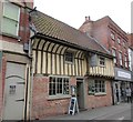
Lombard Street houses
Early 18th century houses on Lombard Street
Image: © Richard Croft
Taken: 7 Feb 2007
0.03 miles
5
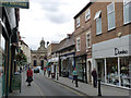
Stodman Street
One of Newark's main shopping streets, looking towards the Corn Exchange.
Image: © Alan Murray-Rust
Taken: 31 Aug 2012
0.03 miles
6
Stodman Street
Newark town centre street
Image: © Richard Croft
Taken: 28 Dec 2012
0.03 miles
7
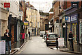
Stodman Street, Newark on Trent, Notts.
A view towards Stodman Street's junction with Castle Gate. The Prince Rupert pub is said to have existed here since 1452.
Image: © David Hallam-Jones
Taken: 29 Oct 2017
0.03 miles
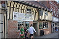
8
The Prince Rupert, Stodman Street
Formerly the Woolpack.
Dates from 1452 and is of type of building common in Kent and Sussex but very rare this far north https://www.britishlistedbuildings.co.uk/101232018-the-woolpack-public-house-newark#.WlvcyDfLjVI
Image: © Jonathan Thacker
Taken: 13 Jan 2018
0.03 miles
9
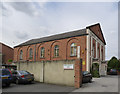
Newark Antiques Centre
The former Independent (later Congregational) chapel off Lombard Street. Built 1822 (architect W Wallen) in neo-classical style. Converted to its current use before 1992. Listed Grade II.
Image: © Alan Murray-Rust
Taken: 31 Aug 2012
0.03 miles
10
57 and 59 Castle Gate, Newark
Dates from about 1700 https://historicengland.org.uk/listing/the-list/list-entry/1228459?section=official-list-entry
Image: © Jonathan Thacker
Taken: 13 Mar 2022
0.03 miles